Ciudad Gustavo Díaz Ordaz night lights from space
Night Light of Ciudad Gustavo Díaz Ordaz (Tamaulipas) from space (Mexico) Src. Average luminocity for 10x10km area is 20.3889% and for 50x50km: 15.0508%.
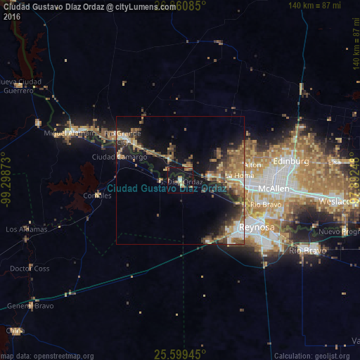
Analysis of Ciudad Gustavo Díaz Ordaz night lights 2016
Square area 10x10 km:
 1.19%
1.19%90-99
0.4%80-89
3.17%70-79
4.56%60-69
2.58%50-59
4.96%40-49
2.98%30-39
1.19%20-29
1.79%10-19
29.56%0-9
47.62%Square area 50x50 km:
1.31%90-99
1.27%80-89
2.24%70-79
2.16%60-69
2.69%50-59
3.88%40-49
2.3%30-39
2.87%20-29
3.72%10-19
9.5%0-9
68.07%Clear (daylight) street map image can be seen on geolist.org.
Map coordinates:
26° 51' 39.1" North, 99° 17' 55.4" West
26° 13' 54.7" North, 98° 35' 44.2" West
25° 35' 58" North, 97° 53' 32.9" West
Some cities around Ciudad Gustavo Díaz Ordaz sort by population:
• Mission, US
27 km =16.8 mi,  93°
93°
• Rio Grande City, US
27.8 km =17.3 mi,  306°
306°
• La Homa, US
23.2 km =14.4 mi,  84°
84°
• Camargo
24.9 km =15.5 mi,  275°
275°
• Palmview, US
22.4 km =13.9 mi, 89°
• Palmview South, US
21.7 km =13.5 mi, 94°
• Perezville, US
19.5 km =12.1 mi, 92°
• Doffing, US
21.4 km =13.3 mi, 77°
3483393 (p: 11,523)
Sources (retrieved 2019-11-25):
» Earth at Night: Flat Maps 2012, 2016