Ciudad Camargo night lights from space
Night Light of Ciudad Camargo (Tamaulipas) from space (Mexico) Src. Average luminocity for 10x10km area is 16.4067% and for 50x50km: 8.4074%.
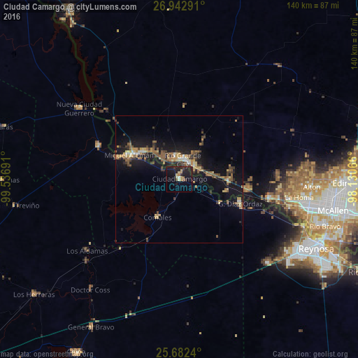
Analysis of Ciudad Camargo night lights 2016
Square area 10x10 km:
 0.4%
0.4%90-99
0.4%80-89
3.97%70-79
0.4%60-69
2.78%50-59
2.18%40-49
0.79%30-39
3.17%20-29
7.74%10-19
26.39%0-9
51.79%Square area 50x50 km:
0.47%90-99
0.44%80-89
1.3%70-79
1.13%60-69
1.35%50-59
2%40-49
1.04%30-39
1.7%20-29
1.69%10-19
9.49%0-9
79.4%Clear (daylight) street map image can be seen on geolist.org.
Map coordinates:
26° 56' 34.5" North, 99° 32' 12.9" West
26° 18' 51.7" North, 98° 50' 1.6" West
25° 40' 56.6" North, 98° 7' 50.4" West
Some cities around Ciudad Camargo sort by population:
• Rio Grande City, US
7.4 km =4.6 mi,  10°
10°
• Roma, US
20.8 km =12.9 mi,  299°
299°
• Camargo
6.7 km =4.2 mi,  188°
188°
• Roma-Los Saenz, US
20.8 km =12.9 mi, 299°
• Palmview, US
47 km =29.2 mi,  101°
101°
• Palmview South, US
46.7 km =29 mi, 103°
• Perezville, US
44.3 km =27.5 mi, 103°
• Doffing, US
44.9 km =27.9 mi, 95°
3530602 (p: 7,984)
Sources (retrieved 2019-11-25):
» Earth at Night: Flat Maps 2012, 2016