Anahuac night lights from space
Night Light of Anahuac (Veracruz) from space (Mexico) Src. Average luminocity for 10x10km area is 56.9905% and for 50x50km: 12.3372%.
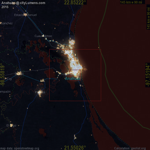
Analysis of Anahuac night lights 2016
Square area 10x10 km:
 13.64%
90-99
11.55%80-89
8.52%70-79
8.9%60-69
10.04%50-59
5.3%40-49
4.73%30-39
4.55%20-29
10.42%10-19
18.56%0-9
3.79%Square area 50x50 km:
2.85%90-99
2.76%80-89
1.34%70-79
1.17%60-69
1.63%50-59
1.04%40-49
1.35%30-39
1.51%20-29
3.67%10-19
5.27%0-9
77.42%Clear (daylight) street map image can be seen on geolist.org.
Map coordinates:
22° 51' 8" North, 98° 33' 29.5" West
22° 12' 9.9" North, 97° 51' 18.2" West
21° 33' 0.9" North, 97° 9' 7" West
Some cities around Anahuac sort by population:
• Tampico
9.5 km =5.9 mi,  345°
345°
• Ciudad Madero
8 km =5 mi,  14°
14°
• Miramar
18.2 km =11.3 mi, 345°
• Altamira
22.7 km =14.1 mi,  337°
337°
• Benito Juárez
1.5 km =0.9 mi,  98°
98°
• Moralillo
6.4 km =4 mi,  293°
293°
• Ciudad Cuauhtémoc
2.9 km =1.8 mi,  134°
134°
• Primero de Mayo
4.4 km =2.7 mi,  55°
55°
3532870 (p: 14,116)
Sources (retrieved 2019-11-25):
» Earth at Night: Flat Maps 2012, 2016