Luchenza night lights from space
Night Light of Luchenza (Southern Region) from space (Malawi) Src. Average luminocity for 10x10km area is 1.8471% and for 50x50km: 1.2817%.
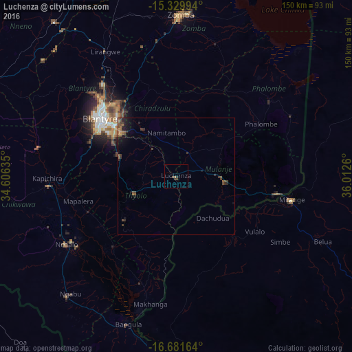
Analysis of Luchenza night lights 2016
Square area 10x10 km:
 0%
0%90-99
0%80-89
0%70-79
0%60-69
0.62%50-59
0.21%40-49
1.65%30-39
0.83%20-29
0.83%10-19
0%0-9
95.87%Square area 50x50 km:
0%90-99
0%80-89
0.03%70-79
0.13%60-69
0.26%50-59
0.46%40-49
0.36%30-39
0.45%20-29
0.44%10-19
1.17%0-9
96.69%Clear (daylight) street map image can be seen on geolist.org.
Map coordinates:
15° 19' 47.8" South, 34° 36' 22.9" East
16° 0' 24.9" South, 35° 18' 34.1" East
16° 40' 53.9" South, 36° 0' 45.4" East
Some cities around Luchenza sort by population:
• Blantyre
40.6 km =25.2 mi,  307°
307°
• Zomba
69.1 km =42.9 mi,  0°
0°
• Liwonde
104.9 km =65.2 mi,  355°
355°
• Nsanje
101.6 km =63.1 mi,  182°
182°
• Mulanje
20.5 km =12.7 mi,  97°
97°
• Mwanza
95.2 km =59.2 mi,  298°
298°
• Chikwawa
54.4 km =33.8 mi,  266°
266°
• Thyolo
19.3 km =12 mi,  249°
249°
927792 (p: 11,939)
Sources (retrieved 2019-11-25):
» Earth at Night: Flat Maps 2012, 2016