Quartier Militaire night lights from space
Night Light of Quartier Militaire (Moka) from space (Mauritius) Src. Average luminocity for 10x10km area is 18.494% and for 50x50km: 18.0548%.
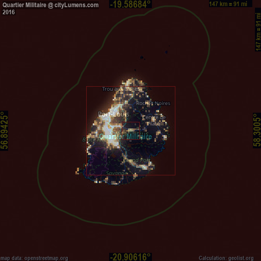
Analysis of Quartier Militaire night lights 2016
Square area 10x10 km:
 0%
0%90-99
0%80-89
0.6%70-79
2.38%60-69
4.37%50-59
1.98%40-49
4.56%30-39
6.35%20-29
9.72%10-19
25.99%0-9
44.05%Square area 50x50 km:
1.67%90-99
2.89%80-89
2.41%70-79
1.78%60-69
2.14%50-59
2.41%40-49
3.91%30-39
4.39%20-29
6.12%10-19
9.36%0-9
62.92%Clear (daylight) street map image can be seen on geolist.org.
Map coordinates:
19° 35' 12.6" South, 56° 53' 39.3" East
20° 14' 52.4" South, 57° 35' 50.5" East
20° 54' 22.2" South, 58° 18' 1.8" East
Some cities around Quartier Militaire sort by population:
• Curepipe
10.6 km =6.6 mi,  224°
224°
• Saint Pierre
8.7 km =5.4 mi,  292°
292°
• Lalmatie
9.3 km =5.8 mi,  45°
45°
• Montagne Blanche
7.6 km =4.7 mi,  123°
123°
• Brisée Verdière
10.7 km =6.6 mi,  28°
28°
• Dagotière
3.7 km =2.3 mi,  275°
275°
• Bon Accueil
10.6 km =6.6 mi,  35°
35°
• Sebastopol
10.6 km =6.6 mi, 116°
934133 (p: 6,424)
Sources (retrieved 2019-11-25):
» Earth at Night: Flat Maps 2012, 2016