Dagotière night lights from space
Night Light of Dagotière (Moka) from space (Mauritius) Src. Average luminocity for 10x10km area is 34.4722% and for 50x50km: 18.1831%.
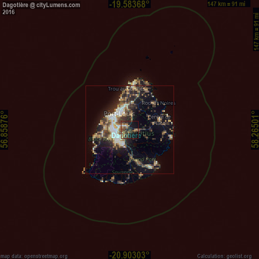
Analysis of Dagotière night lights 2016
Square area 10x10 km:
 0.79%
0.79%90-99
1.19%80-89
4.17%70-79
6.75%60-69
6.55%50-59
8.13%40-49
10.12%30-39
9.92%20-29
12.3%10-19
23.81%0-9
16.27%Square area 50x50 km:
1.67%90-99
2.91%80-89
2.4%70-79
1.78%60-69
2.15%50-59
2.41%40-49
3.96%30-39
4.41%20-29
6.2%10-19
9.48%0-9
62.62%Clear (daylight) street map image can be seen on geolist.org.
Map coordinates:
19° 35' 1.2" South, 56° 51' 31.5" East
20° 14' 41.1" South, 57° 33' 42.8" East
20° 54' 10.9" South, 58° 15' 54" East
Some cities around Dagotière sort by population:
• Beau Bassin-Rose Hill
10.1 km =6.3 mi,  277°
277°
• Vacoas
10.5 km =6.5 mi,  235°
235°
• Curepipe
8.8 km =5.5 mi,  205°
205°
• Quatre Bornes
8.9 km =5.5 mi,  256°
256°
• Saint Pierre
5.2 km =3.2 mi,  305°
305°
• Pailles
9.6 km =6 mi, 306°
• Moka
7.5 km =4.7 mi,  292°
292°
• Quartier Militaire
3.7 km =2.3 mi,  95°
95°
934400 (p: 6,915)
Sources (retrieved 2019-11-25):
» Earth at Night: Flat Maps 2012, 2016