Pointe aux Piments night lights from space
Night Light of Pointe aux Piments (Pamplemousses) from space (Mauritius) Src. Average luminocity for 10x10km area is 30.9127% and for 50x50km: 14.4611%.
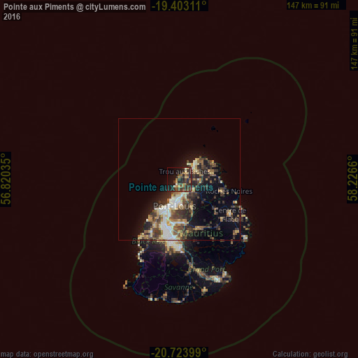
Analysis of Pointe aux Piments night lights 2016
Square area 10x10 km:
 1.39%
1.39%90-99
1.79%80-89
2.78%70-79
5.95%60-69
4.96%50-59
1.79%40-49
10.71%30-39
12.3%20-29
17.26%10-19
20.04%0-9
21.03%Square area 50x50 km:
1.51%90-99
2.3%80-89
2.03%70-79
1.54%60-69
1.68%50-59
1.89%40-49
3.29%30-39
3.5%20-29
4.66%10-19
7.01%0-9
70.58%Clear (daylight) street map image can be seen on geolist.org.
Map coordinates:
19° 24' 11.2" South, 56° 49' 13.3" East
20° 3' 53.8" South, 57° 31' 24.5" East
20° 43' 26.4" South, 58° 13' 35.8" East
Some cities around Pointe aux Piments sort by population:
• Triolet
2.9 km =1.8 mi,  73°
73°
• Le Hochet
7.8 km =4.8 mi,  181°
181°
• Grand Baie
7.9 km =4.9 mi,  48°
48°
• Terre Rouge
6.8 km =4.2 mi, 179°
• Pamplemousses
6.5 km =4 mi,  131°
131°
• Plaine des Papayes
5.1 km =3.2 mi,  90°
90°
• Morcellement Saint André
4.8 km =3 mi,  99°
99°
• Fond du Sac
6.6 km =4.1 mi, 72°
1106614 (p: 7,556)
Sources (retrieved 2019-11-25):
» Earth at Night: Flat Maps 2012, 2016