Victoria night lights from space
Night Light of Victoria from space (Malta) Src. Average luminocity for 10x10km area is 31.9322% and for 50x50km: 8.0573%.
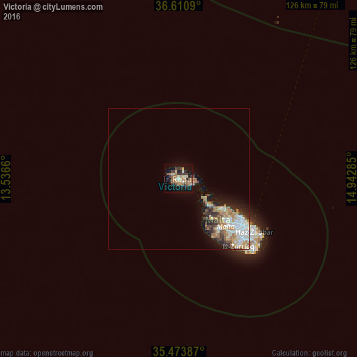
Analysis of Victoria night lights 2016
Square area 10x10 km:
100  1.47%
1.47%
90-99 1.83%
80-89 6.41%
70-79 4.21%
60-69 10.26%
50-59 4.95%
40-49 4.58%
30-39 7.88%
20-29 2.38%
10-19 30.95%
0-9 25.09%
1.47%90-99
1.83%80-89
6.41%70-79
4.21%60-69
10.26%50-59
4.95%40-49
4.58%30-39
7.88%20-29
2.38%10-19
30.95%0-9
25.09%Square area 50x50 km:
100 1.39%
90-99 1.53%
80-89 0.87%
70-79 1.15%
60-69 1.71%
50-59 0.61%
40-49 0.98%
30-39 1.1%
20-29 1.53%
10-19 3.65%
0-9 85.47%
1.39%90-99
1.53%80-89
0.87%70-79
1.15%60-69
1.71%50-59
0.61%40-49
0.98%30-39
1.1%20-29
1.53%10-19
3.65%0-9
85.47%Clear (daylight) street map image can be seen on geolist.org.
Map coordinates:
36° 36' 39.2" North, 13° 32' 11.8" East
36° 2' 40" North, 14° 14' 23" East
35° 28' 25.9" North, 14° 56' 34.3" East
Some cities around Victoria sort by population:
• Xagħra
2.3 km =1.4 mi,  74°
74°
• Xewkija
2.1 km =1.3 mi,  128°
128°
• Saint Lucia
2 km =1.2 mi,  265°
265°
• Żebbuġ
3.1 km =1.9 mi,  353°
353°
• Sannat
2.2 km =1.4 mi,  172°
172°
• Kerċem
1.2 km =0.7 mi,  256°
256°
• Fontana
0.8 km =0.5 mi,  202°
202°
• Munxar
1.7 km =1.1 mi, 199°
2562619 (p: 6,596)
Sources (retrieved 2019-11-25):
» Earth at Night: Flat Maps 2012, 2016