Pembroke night lights from space
Night Light of Pembroke from space (Malta) Src. Average luminocity for 10x10km area is 58.8773% and for 50x50km: 10.3693%.
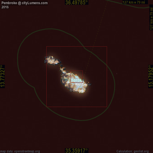
Analysis of Pembroke night lights 2016
Square area 10x10 km:
100  18.68%
90-99 17.95%
80-89 3.48%
70-79 6.04%
60-69 8.61%
50-59 0.73%
40-49 3.66%
30-39 3.3%
20-29 16.3%
10-19 15.57%
0-9 5.68%
18.68%90-99
17.95%80-89
3.48%70-79
6.04%60-69
8.61%50-59
0.73%40-49
3.66%30-39
3.3%20-29
16.3%10-19
15.57%0-9
5.68%Square area 50x50 km:
100 1.79%
90-99 2%
80-89 1.14%
70-79 1.4%
60-69 1.94%
50-59 0.66%
40-49 1.13%
30-39 1.39%
20-29 2.55%
10-19 5.96%
0-9 80.05%
1.79%90-99
2%80-89
1.14%70-79
1.4%60-69
1.94%50-59
0.66%40-49
1.13%30-39
1.39%20-29
2.55%10-19
5.96%0-9
80.05%Clear (daylight) street map image can be seen on geolist.org.
Map coordinates:
36° 29' 52.3" North, 13° 46' 23.8" East
35° 55' 50" North, 14° 28' 35" East
35° 21' 33" North, 15° 10' 46.3" East
Some cities around Pembroke sort by population:
• Saint John
2.8 km =1.7 mi,  180°
180°
• Sliema
3.1 km =1.9 mi,  131°
131°
• Naxxar
3.5 km =2.2 mi,  237°
237°
• Gżira
2.9 km =1.8 mi,  159°
159°
• San Ġiljan
1.8 km =1.1 mi,  138°
138°
• Swieqi
1 km =0.6 mi, 160°
• L-Iklin
3.6 km =2.2 mi,  214°
214°
• Hal Gharghur
2.4 km =1.5 mi,  252°
252°
8337353 (p: 3,038)
Sources (retrieved 2019-11-25):
» Earth at Night: Flat Maps 2012, 2016