Ulcinj night lights from space
Night Light of Ulcinj from space (Montenegro) Src. Average luminocity for 10x10km area is 12.3032% and for 50x50km: 3.0911%.
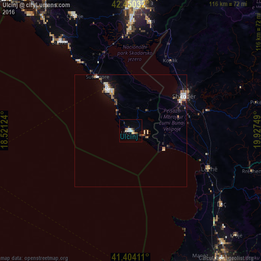
Analysis of Ulcinj night lights 2016
Square area 10x10 km:
 2.38%
2.38%90-99
1.9%80-89
2.06%70-79
0%60-69
1.27%50-59
1.27%40-49
2.06%30-39
0.48%20-29
1.27%10-19
0.63%0-9
86.67%Square area 50x50 km:
0.45%90-99
0.64%80-89
0.28%70-79
0.22%60-69
0.38%50-59
0.45%40-49
0.2%30-39
0.35%20-29
0.44%10-19
2.2%0-9
94.39%Clear (daylight) street map image can be seen on geolist.org.
Map coordinates:
42° 27' 1.2" North, 18° 31' 16.5" East
41° 55' 45.7" North, 19° 13' 27.7" East
41° 24' 14.8" North, 19° 55' 39" East
Some cities around Ulcinj sort by population:
• Podgorica
57 km =35.4 mi,  3°
3°
• Shkodër, AL
28.4 km =17.6 mi,  57°
57°
• Laç, AL
52 km =32.3 mi,  128°
128°
• Lezhë, AL
38.3 km =23.8 mi,  115°
115°
• Budva
50.8 km =31.6 mi,  321°
321°
• Bar
20.9 km =13 mi,  330°
330°
• Rrëshen, AL
56.9 km =35.4 mi,  108°
108°
• Mamurras, AL
55.1 km =34.2 mi,  135°
135°
3188516 (p: 10,828)
Sources (retrieved 2019-11-25):
» Earth at Night: Flat Maps 2012, 2016