Rrëshen night lights from space
Night Light of Rrëshen (Lezhë) from space (Albania) Src. Average luminocity for 10x10km area is 1.3474% and for 50x50km: 0.9262%.
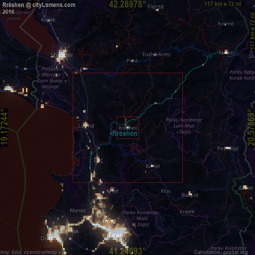
Analysis of Rrëshen night lights 2016
Square area 10x10 km:
100  0%
0%
90-99 0%
80-89 0%
70-79 0%
60-69 0.65%
50-59 0%
40-49 0%
30-39 0.16%
20-29 2.44%
10-19 0.65%
0-9 96.1%
0%90-99
0%80-89
0%70-79
0%60-69
0.65%50-59
0%40-49
0%30-39
0.16%20-29
2.44%10-19
0.65%0-9
96.1%Square area 50x50 km:
100 0.04%
90-99 0.08%
80-89 0.08%
70-79 0.11%
60-69 0.19%
50-59 0.25%
40-49 0.07%
30-39 0.21%
20-29 0.33%
10-19 0.23%
0-9 98.42%
0.04%90-99
0.08%80-89
0.08%70-79
0.11%60-69
0.19%50-59
0.25%40-49
0.07%30-39
0.21%20-29
0.33%10-19
0.23%0-9
98.42%Clear (daylight) street map image can be seen on geolist.org.
Map coordinates:
42° 17' 23.2" North, 19° 10' 20.8" East
41° 46' 3" North, 19° 52' 32" East
41° 14' 27.3" North, 20° 34' 43.3" East
Some cities around Rrëshen sort by population:
• Laç
19.9 km =12.4 mi,  222°
222°
• Krujë
29.5 km =18.3 mi,  193°
193°
• Lezhë
19.3 km =12 mi,  275°
275°
• Burrel
20.7 km =12.9 mi,  147°
147°
• Bulqizë
42.1 km =26.2 mi,  136°
136°
• Fushë-Krujë
34.7 km =21.6 mi,  202°
202°
• Mamurras
26 km =16.2 mi, 215°
• Pukë
30.9 km =19.2 mi,  3°
3°
3184264 (p: 10,064)
Sources (retrieved 2019-11-25):
» Earth at Night: Flat Maps 2012, 2016