Lezhë night lights from space
Night Light of Lezhë from space (Albania) Src. Average luminocity for 10x10km area is 4.914% and for 50x50km: 0.9622%.
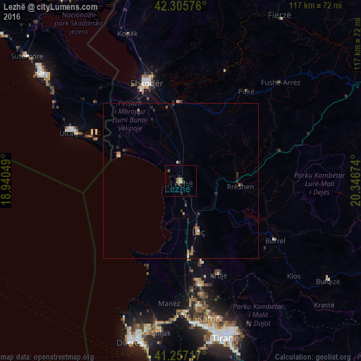
Analysis of Lezhë night lights 2016
Square area 10x10 km:
100  0%
0%
90-99 0%
80-89 1.46%
70-79 0.49%
60-69 0.97%
50-59 2.27%
40-49 0%
30-39 0.16%
20-29 1.46%
10-19 0.65%
0-9 92.53%
0%90-99
0%80-89
1.46%70-79
0.49%60-69
0.97%50-59
2.27%40-49
0%30-39
0.16%20-29
1.46%10-19
0.65%0-9
92.53%Square area 50x50 km:
100 0.02%
90-99 0.06%
80-89 0.1%
70-79 0.11%
60-69 0.23%
50-59 0.23%
40-49 0.09%
30-39 0.18%
20-29 0.39%
10-19 0.21%
0-9 98.37%
0.02%90-99
0.06%80-89
0.1%70-79
0.11%60-69
0.23%50-59
0.23%40-49
0.09%30-39
0.18%20-29
0.39%10-19
0.21%0-9
98.37%Clear (daylight) street map image can be seen on geolist.org.
Map coordinates:
42° 18' 20.7" North, 18° 56' 25.8" East
41° 47' 1" North, 19° 38' 37" East
41° 15' 25.8" North, 20° 20' 48.3" East
Some cities around Lezhë sort by population:
• Shkodër
33.5 km =20.8 mi,  341°
341°
• Laç
17.4 km =10.8 mi,  160°
160°
• Krujë
32.9 km =20.4 mi, 157°
• Burrel
35.9 km =22.3 mi,  122°
122°
• Fushë-Krujë
34.5 km =21.4 mi,  169°
169°
• Rrëshen
19.3 km =12 mi,  95°
95°
• Mamurras
23.3 km =14.5 mi, 170°
• Pukë
35.9 km =22.3 mi,  36°
36°
3184935 (p: 18,695)
Sources (retrieved 2019-11-25):
» Earth at Night: Flat Maps 2012, 2016