Anenii Noi night lights from space
Night Light of Anenii Noi from space (Moldova) Src. Average luminocity for 10x10km area is 0.1905% and for 50x50km: 2.0226%.
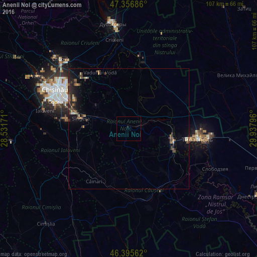
Analysis of Anenii Noi night lights 2016
Square area 10x10 km:
 0%
0%90-99
0%80-89
0%70-79
0%60-69
0%50-59
0%40-49
0%30-39
0%20-29
0.6%10-19
0%0-9
99.4%Square area 50x50 km:
0.08%90-99
0.16%80-89
0.15%70-79
0.19%60-69
0.23%50-59
0.38%40-49
0.62%30-39
0.4%20-29
0.96%10-19
1.45%0-9
95.39%Clear (daylight) street map image can be seen on geolist.org.
Map coordinates:
47° 21' 24.7" North, 28° 31' 54.2" East
46° 52' 42.2" North, 29° 14' 5.4" East
46° 23' 44.2" North, 29° 56' 16.7" East
Some cities around Anenii Noi sort by population:
• Chisinau
31.9 km =19.8 mi,  296°
296°
• Tiraspol
30.2 km =18.8 mi,  97°
97°
• Bender
19.2 km =11.9 mi,  105°
105°
• Căuşeni
30 km =18.6 mi,  153°
153°
• Hryhoriopol
31.1 km =19.3 mi,  9°
9°
• Chiţcani
30.9 km =19.2 mi, 110°
• Sîngera
20.8 km =12.9 mi,  281°
281°
• Vadul lui Vodă
26.5 km =16.5 mi,  332°
332°
617702 (p: 8,250)
Sources (retrieved 2019-11-25):
» Earth at Night: Flat Maps 2012, 2016