Hryhoriopol night lights from space
Night Light of Hryhoriopol (Transnistria) from space (Moldova) Src. Average luminocity for 10x10km area is 1.1378% and for 50x50km: 1.1066%.
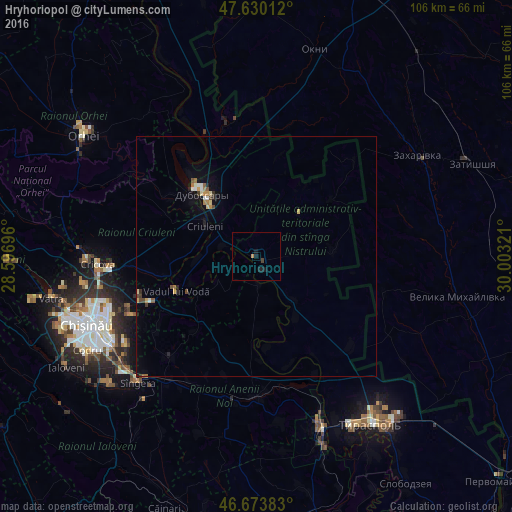
Analysis of Hryhoriopol night lights 2016
Square area 10x10 km:
 0%
0%90-99
0%80-89
0%70-79
0.57%60-69
0%50-59
0%40-49
0%30-39
0.57%20-29
0%10-19
2.84%0-9
96.02%Square area 50x50 km:
0.09%90-99
0.12%80-89
0.15%70-79
0.15%60-69
0.18%50-59
0.09%40-49
0.18%30-39
0.13%20-29
0.19%10-19
0.46%0-9
98.25%Clear (daylight) street map image can be seen on geolist.org.
Map coordinates:
47° 37' 48.4" North, 28° 35' 49.1" East
47° 9' 14.9" North, 29° 18' 0.3" East
46° 40' 25.8" North, 30° 0' 11.6" East
Some cities around Hryhoriopol sort by population:
• Dubăsari
16 km =9.9 mi,  320°
320°
• Anenii Noi
31.1 km =19.3 mi,  189°
189°
• Cricova
33.2 km =20.6 mi,  266°
266°
• Criuleni
12.5 km =7.8 mi,  301°
301°
• Ciorescu
31.2 km =19.4 mi, 265°
• Stăuceni
33.3 km =20.7 mi,  258°
258°
• Vadul lui Vodă
18.4 km =11.4 mi,  247°
247°
• Cocieri
21.4 km =13.3 mi, 319°
618234 (p: 9,456)
Sources (retrieved 2019-11-25):
» Earth at Night: Flat Maps 2012, 2016