Grevenmacher night lights from space
Night Light of Grevenmacher from space (Luxembourg) Src. Average luminocity for 10x10km area is 11.631% and for 50x50km: 11.154%.
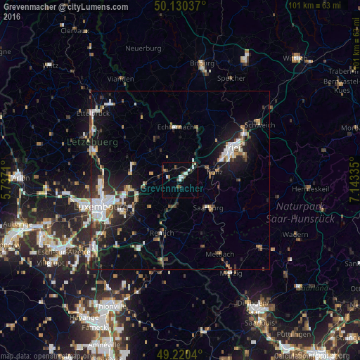
Analysis of Grevenmacher night lights 2016
Square area 10x10 km:
 1.87%
1.87%90-99
2.41%80-89
0.53%70-79
0.53%60-69
1.07%50-59
1.47%40-49
3.74%30-39
0.13%20-29
1.6%10-19
0.67%0-9
85.96%Square area 50x50 km:
1.99%90-99
2.2%80-89
0.89%70-79
0.87%60-69
1.05%50-59
1.23%40-49
1.43%30-39
1.76%20-29
3.09%10-19
7.76%0-9
77.72%Clear (daylight) street map image can be seen on geolist.org.
Map coordinates:
50° 7' 49.3" North, 5° 44' 13.6" East
49° 40' 39" North, 6° 26' 24.8" East
49° 13' 13.4" North, 7° 8' 36.1" East
Some cities around Grevenmacher sort by population:
• Trier, DE
16.7 km =10.4 mi,  58°
58°
• Luxembourg
23.5 km =14.6 mi,  251°
251°
• Konz, DE
10.1 km =6.3 mi,  75°
75°
• Losheim, DE
28.8 km =17.9 mi,  130°
130°
• Schweich, DE
27.6 km =17.1 mi,  54°
54°
• Saarburg, DE
10.9 km =6.8 mi,  136°
136°
• Strassen
27.2 km =16.9 mi,  256°
256°
• Mersch
25.3 km =15.7 mi,  288°
288°
2960515 (p: 3,958)
Sources (retrieved 2019-11-25):
» Earth at Night: Flat Maps 2012, 2016