Konz night lights from space
Night Light of Konz (Rheinland-Pfalz) from space (Germany) Src. Average luminocity for 10x10km area is 17.0829% and for 50x50km: 5.4012%.
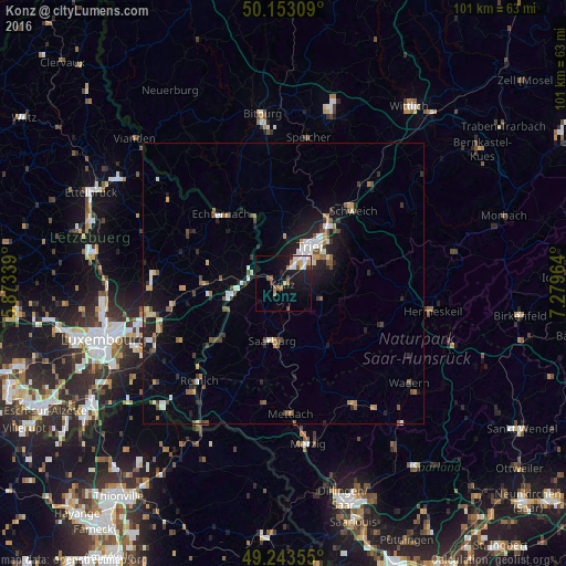
Analysis of Konz night lights 2016
Square area 10x10 km:
 2.41%
2.41%90-99
3.88%80-89
0.67%70-79
1.74%60-69
3.48%50-59
0.4%40-49
2.27%30-39
1.47%20-29
2.67%10-19
16.44%0-9
64.57%Square area 50x50 km:
0.6%90-99
0.86%80-89
0.41%70-79
0.56%60-69
0.6%50-59
0.75%40-49
0.91%30-39
0.58%20-29
1.51%10-19
3.93%0-9
89.3%Clear (daylight) street map image can be seen on geolist.org.
Map coordinates:
50° 9' 11.1" North, 5° 52' 24.2" East
49° 42' 1.6" North, 6° 34' 35.5" East
49° 14' 36.8" North, 7° 16' 46.7" East
Some cities around Konz sort by population:
• Trier
7.6 km =4.7 mi,  36°
36°
• Wadern
28.6 km =17.8 mi,  128°
128°
• Losheim
24.4 km =15.2 mi,  150°
150°
• Schweich
18.5 km =11.5 mi, 43°
• Weiskirchen
24.1 km =15 mi, 134°
• Saarburg
10.7 km =6.6 mi,  192°
192°
• Hermeskeil
26.9 km =16.7 mi,  100°
100°
• Grevenmacher, LU
10.1 km =6.3 mi,  255°
255°
2885672 (p: 17,879)
Sources (retrieved 2019-11-25):
» Earth at Night: Flat Maps 2012, 2016