Diekirch night lights from space
Night Light of Diekirch from space (Luxembourg) Src. Average luminocity for 10x10km area is 15.0348% and for 50x50km: 5.6322%.
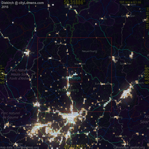
Analysis of Diekirch night lights 2016
Square area 10x10 km:
 3.07%
3.07%90-99
3.88%80-89
1.07%70-79
0%60-69
1.6%50-59
1.2%40-49
2.01%30-39
0.53%20-29
1.6%10-19
13.9%0-9
71.12%Square area 50x50 km:
0.66%90-99
0.77%80-89
0.52%70-79
0.51%60-69
0.61%50-59
0.63%40-49
0.8%30-39
0.87%20-29
1.52%10-19
5.56%0-9
87.57%Clear (daylight) street map image can be seen on geolist.org.
Map coordinates:
50° 19' 7.9" North, 5° 27' 9.8" East
49° 52' 4" North, 6° 9' 21" East
49° 24' 44.8" North, 6° 51' 32.3" East
Some cities around Diekirch sort by population:
• Luxembourg
28.5 km =17.7 mi,  183°
183°
• Bitburg, DE
28.8 km =17.9 mi,  67°
67°
• Ettelbruck
4.3 km =2.7 mi,  238°
238°
• Strassen
28.1 km =17.5 mi,  192°
192°
• Mamer
28.4 km =17.6 mi,  199°
199°
• Wiltz
19.2 km =11.9 mi,  304°
304°
• Mersch
13.7 km =8.5 mi, 195°
• Redange-sur-Attert
22.3 km =13.9 mi, 238°
2960657 (p: 6,242)
Sources (retrieved 2019-11-25):
» Earth at Night: Flat Maps 2012, 2016