Planken night lights from space
Night Light of Planken from space (Liechtenstein) Src. Average luminocity for 10x10km area is 17.0729% and for 50x50km: 5.7534%.
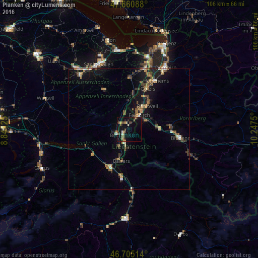
Analysis of Planken night lights 2016
Square area 10x10 km:
100  0.15%
0.15%
90-99 2.68%
80-89 1.93%
70-79 2.98%
60-69 2.23%
50-59 2.38%
40-49 2.53%
30-39 2.23%
20-29 1.79%
10-19 22.47%
0-9 58.63%
0.15%90-99
2.68%80-89
1.93%70-79
2.98%60-69
2.23%50-59
2.38%40-49
2.53%30-39
2.23%20-29
1.79%10-19
22.47%0-9
58.63%Square area 50x50 km:
100 0.24%
90-99 0.56%
80-89 0.41%
70-79 0.88%
60-69 0.99%
50-59 0.89%
40-49 1.16%
30-39 0.92%
20-29 1.14%
10-19 5.47%
0-9 87.32%
0.24%90-99
0.56%80-89
0.41%70-79
0.88%60-69
0.99%50-59
0.89%40-49
1.16%30-39
0.92%20-29
1.14%10-19
5.47%0-9
87.32%Clear (daylight) street map image can be seen on geolist.org.
Map coordinates:
47° 39' 39.2" North, 8° 50' 28.5" East
47° 11' 6.6" North, 9° 32' 39.7" East
46° 42' 18.5" North, 10° 14' 51" East
Some cities around Planken sort by population:
• Buchs, CH
5.4 km =3.4 mi,  248°
248°
• Schaan
3.5 km =2.2 mi,  230°
230°
• Vaduz
5.2 km =3.2 mi,  199°
199°
• Eschen
3.3 km =2.1 mi,  329°
329°
• Mauren
3.7 km =2.3 mi,  359°
359°
• Ruggell
6 km =3.7 mi,  346°
346°
• Gamprin
4.7 km =2.9 mi, 325°
• Schellenberg
5.1 km =3.2 mi,  2°
2°
3042049 (p: 377)
Sources (retrieved 2019-11-25):
» Earth at Night: Flat Maps 2012, 2016