Yeonil night lights from space
Night Light of Yeonil (Gyeongsangbuk-do) from space (South Korea) Src. Average luminocity for 10x10km area is 83.1996% and for 50x50km: 20.5765%.
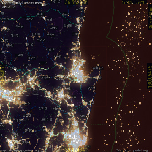

Analysis of Yeonil night lights 2016
Square area 10x10 km:
 31.14%
90-99
29.85%80-89
5.86%70-79
8.24%60-69
7.69%50-59
4.58%40-49
3.66%30-39
7.33%20-29
1.65%10-19
0%0-9
0%Square area 50x50 km:
2.28%90-99
3.66%80-89
2.04%70-79
2.56%60-69
2.93%50-59
3.46%40-49
2.77%30-39
4.58%20-29
6.22%10-19
13.56%0-9
55.94%Clear (daylight) street map image can be seen on geolist.org.
Map coordinates:
36° 33' 43.5" North, 128° 38' 54.6" East
35° 59' 42.9" North, 129° 21' 5.8" East
35° 25' 27.6" North, 130° 3' 17.1" East
Some cities around Yeonil sort by population:
• Ulsan
51 km =31.7 mi,  183°
183°
• Pohang
4 km =2.5 mi,  17°
17°
• Gyeongju
21.1 km =13.1 mi,  216°
216°
• Gyeongsan-si
58.5 km =36.4 mi,  250°
250°
• Eisen
38 km =23.6 mi,  265°
265°
• Hayang
48.7 km =30.3 mi,  259°
259°
• Heunghae
12.7 km =7.9 mi,  357°
357°
• Cheongsong gun
55.4 km =34.4 mi,  331°
331°
1832215 (p: 40,852)
Sources (retrieved 2019-11-25):
» Earth at Night: Flat Maps 2012, 2016