Yonggang-ŭp night lights from space
Night Light of Yonggang-ŭp (South Pyongan) from space (North Korea) Src. Average luminocity for 10x10km area is 0% and for 50x50km: 0.9243%.
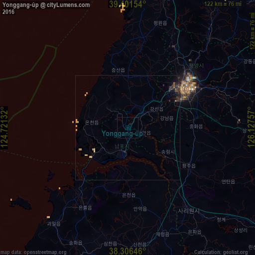
Analysis of Yonggang-ŭp night lights 2016
Square area 10x10 km:
 0%
0%90-99
0%80-89
0%70-79
0%60-69
0%50-59
0%40-49
0%30-39
0%20-29
0%10-19
0%0-9
100%Square area 50x50 km:
0%90-99
0.05%80-89
0.21%70-79
0.2%60-69
0.04%50-59
0.08%40-49
0.1%30-39
0.37%20-29
0.37%10-19
0.54%0-9
98.04%Clear (daylight) street map image can be seen on geolist.org.
Map coordinates:
39° 24' 5.5" North, 124° 43' 16.8" East
38° 51' 22" North, 125° 25' 28" East
38° 18' 23.3" North, 126° 7' 39.3" East
Some cities around Yonggang-ŭp sort by population:
• Pyongyang
34.7 km =21.6 mi,  55°
55°
• Namp’o
13.3 km =8.3 mi,  186°
186°
• Songnim
22.2 km =13.8 mi,  120°
120°
• Sunan
44.4 km =27.6 mi,  31°
31°
• Hwangju-ŭp
36.8 km =22.9 mi, 124°
• Hŭkkyo-ri
32.5 km =20.2 mi,  101°
101°
• Anak
38.9 km =24.2 mi,  171°
171°
• Chunghwa
32.5 km =20.2 mi,  88°
88°
1866362 (p: 13,440)
Sources (retrieved 2019-11-25):
» Earth at Night: Flat Maps 2012, 2016