Kinango night lights from space
Night Light of Kinango (Kwale) from space (Kenya) Src. Average luminocity for 10x10km area is 0.2684% and for 50x50km: 0.4781%.
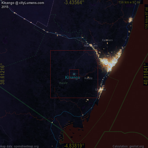
Analysis of Kinango night lights 2016
Square area 10x10 km:
100  0%
0%
90-99 0%
80-89 0%
70-79 0%
60-69 0%
50-59 0%
40-49 0%
30-39 0.43%
20-29 0.43%
10-19 0%
0-9 99.13%
0%90-99
0%80-89
0%70-79
0%60-69
0%50-59
0%40-49
0%30-39
0.43%20-29
0.43%10-19
0%0-9
99.13%Square area 50x50 km:
100 0%
90-99 0%
80-89 0%
70-79 0.08%
60-69 0.13%
50-59 0.05%
40-49 0.13%
30-39 0.06%
20-29 0.08%
10-19 0.22%
0-9 99.26%
0%90-99
0%80-89
0%70-79
0.08%60-69
0.13%50-59
0.05%40-49
0.13%30-39
0.06%20-29
0.08%10-19
0.22%0-9
99.26%Clear (daylight) street map image can be seen on geolist.org.
Map coordinates:
3° 26' 8.3" South, 38° 36' 43.8" East
4° 8' 14" South, 39° 18' 55" East
4° 50' 17.5" South, 40° 1' 6.3" East
Some cities around Kinango sort by population:
• Mombasa
39.7 km =24.7 mi,  76°
76°
• Kilifi
81.8 km =50.8 mi,  46°
46°
• Mlalo, TZ
98.1 km =61 mi,  205°
205°
• Sawa Sawa
41.7 km =25.9 mi,  153°
153°
• Mariakani
35.3 km =21.9 mi,  30°
30°
• Takaungu
78.5 km =48.8 mi, 49°
• Gazi
38.3 km =23.8 mi, 146°
• Kwale
15.7 km =9.8 mi,  104°
104°
191833 (p: 8,070)
Sources (retrieved 2019-11-25):
» Earth at Night: Flat Maps 2012, 2016