Kilifi night lights from space
Night Light of Kilifi from space (Kenya) Src. Average luminocity for 10x10km area is 13.7576% and for 50x50km: 0.76%.
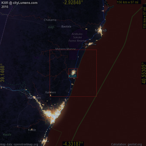

Analysis of Kilifi night lights 2016
Square area 10x10 km:
100  0%
0%
90-99 0.87%
80-89 0.87%
70-79 4.55%
60-69 1.52%
50-59 3.03%
40-49 3.9%
30-39 3.25%
20-29 2.16%
10-19 2.6%
0-9 77.27%
0%90-99
0.87%80-89
0.87%70-79
4.55%60-69
1.52%50-59
3.03%40-49
3.9%30-39
3.25%20-29
2.16%10-19
2.6%0-9
77.27%Square area 50x50 km:
100 0%
90-99 0.03%
80-89 0.03%
70-79 0.22%
60-69 0.09%
50-59 0.16%
40-49 0.24%
30-39 0.27%
20-29 0.12%
10-19 0.1%
0-9 98.73%
0%90-99
0.03%80-89
0.03%70-79
0.22%60-69
0.09%50-59
0.16%40-49
0.24%30-39
0.27%20-29
0.12%10-19
0.1%0-9
98.73%Clear (daylight) street map image can be seen on geolist.org.
Map coordinates:
2° 55' 42.5" South, 39° 8' 48.5" East
3° 37' 49.6" South, 39° 50' 59.7" East
4° 19' 54.7" South, 40° 33' 11" East
Some cities around Kilifi sort by population:
• Mombasa
51.5 km =32 mi,  203°
203°
• Malindi
54.6 km =33.9 mi,  32°
32°
• Sawa Sawa
101.9 km =63.3 mi, 203°
• Mariakani
49 km =30.4 mi,  238°
238°
• Takaungu
5.9 km =3.7 mi,  172°
172°
• Kinango
81.8 km =50.8 mi,  226°
226°
• Gazi
96.1 km =59.7 mi, 203°
• Kwale
74.8 km =46.5 mi,  216°
216°
192067 (p: 46,118)
Sources (retrieved 2019-11-25):
» Earth at Night: Flat Maps 2012, 2016