Gazi night lights from space
Night Light of Gazi (Kwale) from space (Kenya) Src. Average luminocity for 10x10km area is 0.4814% and for 50x50km: 1.3652%.
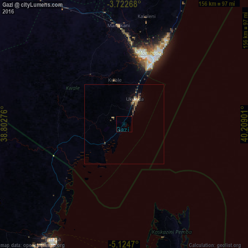
Analysis of Gazi night lights 2016
Square area 10x10 km:
 0%
0%90-99
0%80-89
0%70-79
0%60-69
0%50-59
0%40-49
0.41%30-39
0%20-29
0.83%10-19
0%0-9
98.76%Square area 50x50 km:
0.02%90-99
0.06%80-89
0.26%70-79
0.22%60-69
0.11%50-59
0.23%40-49
0.39%30-39
0.39%20-29
0.16%10-19
0.69%0-9
97.47%Clear (daylight) street map image can be seen on geolist.org.
Map coordinates:
3° 43' 21.6" South, 38° 48' 9.9" East
4° 25' 26.5" South, 39° 30' 21.2" East
5° 7' 28.9" South, 40° 12' 32.4" East
Some cities around Gazi sort by population:
• Mombasa
44.6 km =27.7 mi,  23°
23°
• Wete, TZ
74.5 km =46.3 mi,  160°
160°
• Sawa Sawa
5.8 km =3.6 mi,  203°
203°
• Mariakani
62.5 km =38.8 mi,  356°
356°
• Micheweni, TZ
70.4 km =43.7 mi,  148°
148°
• Konde, TZ
64.4 km =40 mi, 155°
• Kinango
38.3 km =23.8 mi,  326°
326°
• Kwale
28.5 km =17.7 mi,  347°
347°
197514 (p: 5,222)
Sources (retrieved 2019-11-25):
» Earth at Night: Flat Maps 2012, 2016