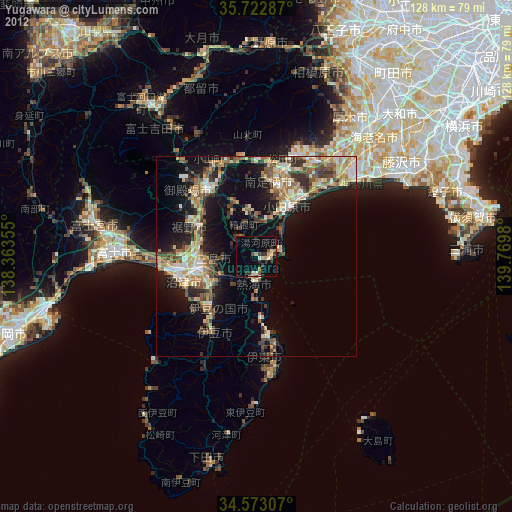
Yugawara night lights from space
Night Light of Yugawara (Kanagawa) from space (Japan) Src. Average luminocity for 10x10km area is 14.6241% and for 50x50km: 16.3349%.

Analysis of Yugawara night lights 2016
Square area 10x10 km:
100  0.87%
0.87%
90-99 2.27%
80-89 0.7%
70-79 1.92%
60-69 0.87%
50-59 4.2%
40-49 2.62%
30-39 1.92%
20-29 3.32%
10-19 4.37%
0-9 76.92%
0.87%90-99
2.27%80-89
0.7%70-79
1.92%60-69
0.87%50-59
4.2%40-49
2.62%30-39
1.92%20-29
3.32%10-19
4.37%0-9
76.92%Square area 50x50 km:
100 1.61%
90-99 2.48%
80-89 1.56%
70-79 2.27%
60-69 2.17%
50-59 2.49%
40-49 3.44%
30-39 3.17%
20-29 5.42%
10-19 10.7%
0-9 64.7%
1.61%90-99
2.48%80-89
1.56%70-79
2.27%60-69
2.17%50-59
2.49%40-49
3.44%30-39
3.17%20-29
5.42%10-19
10.7%0-9
64.7%Clear (daylight) street map image can be seen on geolist.org.
Map coordinates:
35° 43' 22.3" North, 138° 21' 48.8" East
35° 9' 0" North, 139° 4' 0" East
34° 34' 23.1" North, 139° 46' 11.3" East
Some cities around Yugawara sort by population:
• Numazu
19 km =11.8 mi,  253°
253°
• Odawara
14.5 km =9 mi,  35°
35°
• Mishima
14.1 km =8.8 mi, 254°
• Gotenba
21.8 km =13.5 mi,  329°
329°
• Itō
20.4 km =12.7 mi,  175°
175°
• Atami
7 km =4.3 mi,  190°
190°
• Ninomiya
24.1 km =15 mi,  45°
45°
• Hakone
5.7 km =3.5 mi,  320°
320°
1848113 (p: 27,567)
Sources (retrieved 2019-11-25):
» Earth at Night: Flat Maps 2012, 2016