Yoshitomi night lights from space
Night Light of Yoshitomi (Fukuoka) from space (Japan) Src. Average luminocity for 10x10km area is 33.6392% and for 50x50km: 6.0132%.
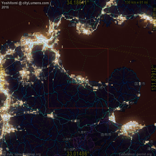
Analysis of Yoshitomi night lights 2016
Square area 10x10 km:
 0.92%
0.92%90-99
1.65%80-89
6.41%70-79
4.4%60-69
8.24%50-59
11.54%40-49
3.11%30-39
5.13%20-29
8.61%10-19
33.7%0-9
16.3%Square area 50x50 km:
0.17%90-99
0.5%80-89
0.86%70-79
0.68%60-69
1.21%50-59
1.34%40-49
0.84%30-39
1.17%20-29
2.01%10-19
4.8%0-9
86.43%Clear (daylight) street map image can be seen on geolist.org.
Map coordinates:
34° 11' 10" North, 130° 28' 22.3" East
33° 36' 8.9" North, 131° 10' 33.6" East
33° 0' 53.5" North, 131° 52' 44.8" East
Some cities around Yoshitomi sort by population:
• Yukuhashi
22.7 km =14.1 mi,  308°
308°
• Nakatsu
1.2 km =0.7 mi,  113°
113°
• Kanda
26.9 km =16.7 mi,  318°
318°
• Buzen
4.4 km =2.7 mi,  283°
283°
• Bungo-Takada-shi
25.4 km =15.8 mi,  101°
101°
• Kawasaki
33.4 km =20.8 mi,  269°
269°
• Shiida
12.3 km =7.6 mi,  297°
297°
• Tsuiki
15 km =9.3 mi, 301°
8198710 (p: 6,875)
Sources (retrieved 2019-11-25):
» Earth at Night: Flat Maps 2012, 2016