Tonoshō night lights from space
Night Light of Tonoshō (Kagawa) from space (Japan) Src. Average luminocity for 10x10km area is 4.3811% and for 50x50km: 10.9127%.
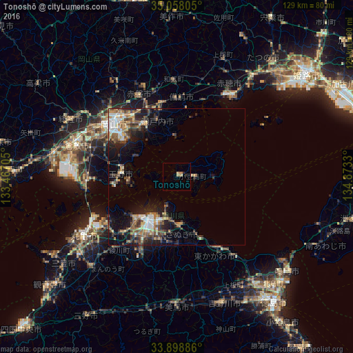
Analysis of Tonoshō night lights 2016
Square area 10x10 km:
 0%
0%90-99
0.17%80-89
1.92%70-79
0%60-69
2.1%50-59
0%40-49
0%30-39
0%20-29
1.4%10-19
0%0-9
94.41%Square area 50x50 km:
1.2%90-99
1.61%80-89
1.33%70-79
1.19%60-69
1.66%50-59
2.09%40-49
2.1%30-39
1.69%20-29
3.15%10-19
6.26%0-9
77.73%Clear (daylight) street map image can be seen on geolist.org.
Map coordinates:
35° 3' 29" North, 133° 28' 1.4" East
34° 28' 49.7" North, 134° 10' 12.6" East
33° 53' 55.9" North, 134° 52' 23.9" East
Some cities around Tonoshō sort by population:
• Okayama
28.7 km =17.8 mi,  310°
310°
• Kurashiki
38.7 km =24 mi,  287°
287°
• Takamatsu
19.7 km =12.2 mi,  213°
213°
• Marugame
41.7 km =25.9 mi,  238°
238°
• Tamano
21 km =13 mi,  281°
281°
• Sakaidechō
35.3 km =21.9 mi, 240°
• Kariya
36.1 km =22.4 mi,  33°
33°
• Shido
17.5 km =10.9 mi,  179°
179°
1850004 (p: 16,514)
Sources (retrieved 2019-11-25):
» Earth at Night: Flat Maps 2012, 2016