Miyazu night lights from space
Night Light of Miyazu (Kyoto) from space (Japan) Src. Average luminocity for 10x10km area is 5.5311% and for 50x50km: 2.1711%.
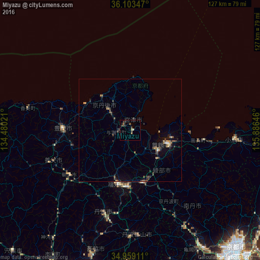

Analysis of Miyazu night lights 2016
Square area 10x10 km:
 0%
0%90-99
0.18%80-89
0.55%70-79
1.47%60-69
0.37%50-59
0.37%40-49
3.66%30-39
0.73%20-29
2.56%10-19
0.73%0-9
89.38%Square area 50x50 km:
0.05%90-99
0.1%80-89
0.31%70-79
0.18%60-69
0.27%50-59
0.47%40-49
0.58%30-39
0.46%20-29
0.74%10-19
0.95%0-9
95.89%Clear (daylight) street map image can be seen on geolist.org.
Map coordinates:
36° 6' 12.5" North, 134° 28' 48.8" East
35° 31' 60" North, 135° 10' 60" East
34° 57' 32.8" North, 135° 53' 11.3" East
Some cities around Miyazu sort by population:
• Kameoka
69.5 km =43.2 mi,  148°
148°
• Maizuru
16.4 km =10.2 mi,  124°
124°
• Fukuchiyama
26.6 km =16.5 mi,  193°
193°
• Sasayama
52 km =32.3 mi,  176°
176°
• Toyooka
32.8 km =20.4 mi,  271°
271°
• Ayabe
26.6 km =16.5 mi,  166°
166°
• Nishiwaki
63.9 km =39.7 mi,  197°
197°
• Obama
51.1 km =31.8 mi,  94°
94°
1856703 (p: 21,632)
Sources (retrieved 2019-11-25):
» Earth at Night: Flat Maps 2012, 2016