Mitsuke night lights from space
Night Light of Mitsuke (Niigata) from space (Japan) Src. Average luminocity for 10x10km area is 13.1055% and for 50x50km: 5.2859%.
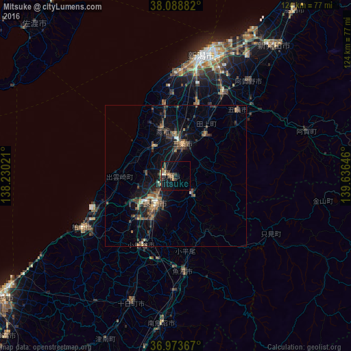
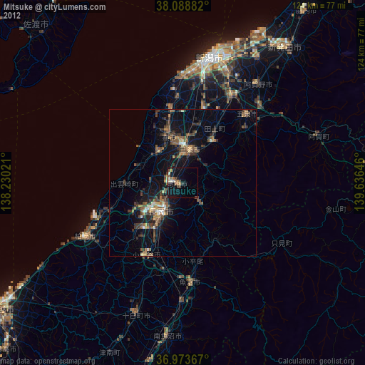
Analysis of Mitsuke night lights 2016
Square area 10x10 km:
 0.49%
0.49%90-99
0.16%80-89
1.3%70-79
2.6%60-69
2.6%50-59
2.76%40-49
2.92%30-39
2.76%20-29
1.14%10-19
11.04%0-9
72.24%Square area 50x50 km:
0.12%90-99
0.31%80-89
0.39%70-79
0.4%60-69
0.92%50-59
1.17%40-49
1.7%30-39
1.53%20-29
1.41%10-19
3.95%0-9
88.11%Clear (daylight) street map image can be seen on geolist.org.
Map coordinates:
38° 5' 19.8" North, 138° 13' 48.8" East
37° 31' 60" North, 138° 55' 60" East
36° 58' 25.2" North, 139° 38' 11.3" East
Some cities around Mitsuke sort by population:
• Nagaoka
11.8 km =7.3 mi,  218°
218°
• Sanjō
9.4 km =5.8 mi,  9°
9°
• Tsubame
14.6 km =9.1 mi,  357°
357°
• Shirone
26.8 km =16.7 mi,  16°
16°
• Kamo
17.1 km =10.6 mi,  31°
31°
• Maki
24.5 km =15.2 mi,  349°
349°
• Yoshida-kasugachō
17.3 km =10.7 mi, 345°
• Tochio-honchō
8.4 km =5.2 mi,  139°
139°
1856878 (p: 43,180)
Sources (retrieved 2019-11-25):
» Earth at Night: Flat Maps 2012, 2016