Kanaya night lights from space
Night Light of Kanaya (Shizuoka) from space (Japan) Src. Average luminocity for 10x10km area is 29.6758% and for 50x50km: 18.0506%.
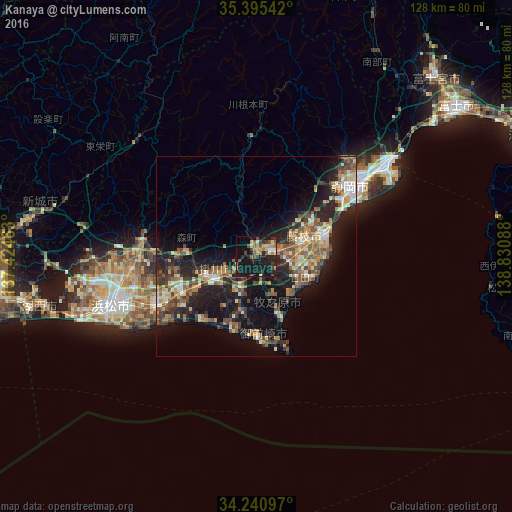

Analysis of Kanaya night lights 2016
Square area 10x10 km:
 1.28%
1.28%90-99
2.93%80-89
4.95%70-79
3.66%60-69
3.85%50-59
5.68%40-49
6.23%30-39
4.21%20-29
8.24%10-19
46.34%0-9
12.64%Square area 50x50 km:
1.02%90-99
2.4%80-89
2.32%70-79
2.53%60-69
2.73%50-59
3.65%40-49
3.51%30-39
2.9%20-29
6.86%10-19
14.76%0-9
57.31%Clear (daylight) street map image can be seen on geolist.org.
Map coordinates:
35° 23' 43.5" North, 137° 25' 28.7" East
34° 49' 12.8" North, 138° 7' 39.9" East
34° 14' 27.5" North, 138° 49' 51.2" East
Some cities around Kanaya sort by population:
• Fujieda
13.7 km =8.5 mi,  67°
67°
• Yaizu
18.3 km =11.4 mi, 72°
• Kakegawa
11.8 km =7.3 mi,  239°
239°
• Shimada
5.1 km =3.2 mi,  94°
94°
• Fukuroi
20.8 km =12.9 mi,  247°
247°
• Sagara
16.6 km =10.3 mi,  154°
154°
• Ōyama
25.4 km =15.8 mi,  161°
161°
• Mori
17.8 km =11.1 mi,  274°
274°
1860256 (p: 20,286)
Sources (retrieved 2019-11-25):
» Earth at Night: Flat Maps 2012, 2016