Ichinohe night lights from space
Night Light of Ichinohe (Iwate) from space (Japan) Src. Average luminocity for 10x10km area is 2.2581% and for 50x50km: 0.6586%.
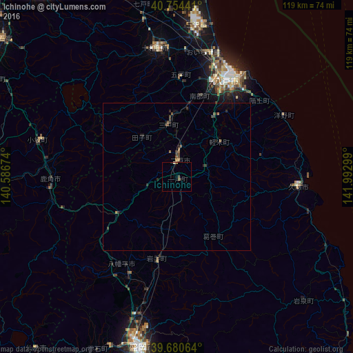
Analysis of Ichinohe night lights 2016
Square area 10x10 km:
 0%
0%90-99
0.65%80-89
0%70-79
0%60-69
0.32%50-59
0.97%40-49
0.65%30-39
0%20-29
0.65%10-19
0%0-9
96.75%Square area 50x50 km:
0%90-99
0.03%80-89
0.03%70-79
0.06%60-69
0.11%50-59
0.18%40-49
0.24%30-39
0.26%20-29
0.23%10-19
0.15%0-9
98.72%Clear (daylight) street map image can be seen on geolist.org.
Map coordinates:
40° 45' 15.9" North, 140° 35' 12.3" East
40° 13' 10.7" North, 141° 17' 23.5" East
39° 40' 50.3" North, 141° 59' 34.8" East
Some cities around Ichinohe sort by population:
• Morioka
59 km =36.7 mi,  191°
191°
• Hachinohe
35.9 km =22.3 mi,  29°
29°
• Ōdate
62.4 km =38.8 mi,  275°
275°
• Misawa
52.6 km =32.7 mi,  9°
9°
• Kuroishi
76.3 km =47.4 mi,  308°
308°
• Hanawa
42.9 km =26.7 mi,  264°
264°
• Takanosu
78.4 km =48.7 mi,  270°
270°
• Shizukuishi
64 km =39.8 mi,  204°
204°
2129961 (p: 15,825)
Sources (retrieved 2019-11-25):
» Earth at Night: Flat Maps 2012, 2016