Safi night lights from space
Night Light of Safi (Karak) from space (Jordan) Src. Average luminocity for 10x10km area is 11.5952% and for 50x50km: 8.623%.
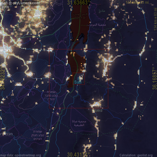
Analysis of Safi night lights 2016
Square area 10x10 km:
 1.1%
1.1%90-99
1.1%80-89
0.73%70-79
1.28%60-69
1.28%50-59
1.83%40-49
3.11%30-39
2.2%20-29
2.56%10-19
4.21%0-9
80.59%Square area 50x50 km:
0.85%90-99
1.03%80-89
0.94%70-79
1.79%60-69
0.75%50-59
0.79%40-49
1.68%30-39
1.55%20-29
2.59%10-19
4.95%0-9
83.07%Clear (daylight) street map image can be seen on geolist.org.
Map coordinates:
31° 38' 11.9" North, 34° 45' 44.4" East
31° 2' 9.9" North, 35° 27' 55.6" East
30° 25' 54.2" North, 36° 10' 6.9" East
Some cities around Safi sort by population:
• Aţ Ţafīlah
25.8 km =16 mi,  149°
149°
• Arad, IL
34.5 km =21.4 mi,  315°
315°
• ‘Izrā
25.6 km =15.9 mi,  57°
57°
• Qīr Moāv
27.6 km =17.1 mi,  53°
53°
• Karak City
31.6 km =19.6 mi, 63°
• Al Mazār al Janūbī
22.1 km =13.7 mi,  80°
80°
• ‘Ayy
20.2 km =12.6 mi, 57°
• Al Khinzīrah
13.5 km =8.4 mi, 83°
250267 (p: 15,200)
Sources (retrieved 2019-11-25):
» Earth at Night: Flat Maps 2012, 2016