Kurayyimah night lights from space
Night Light of Kurayyimah (Irbid) from space (Jordan) Src. Average luminocity for 10x10km area is 22.2747% and for 50x50km: 31.7444%.
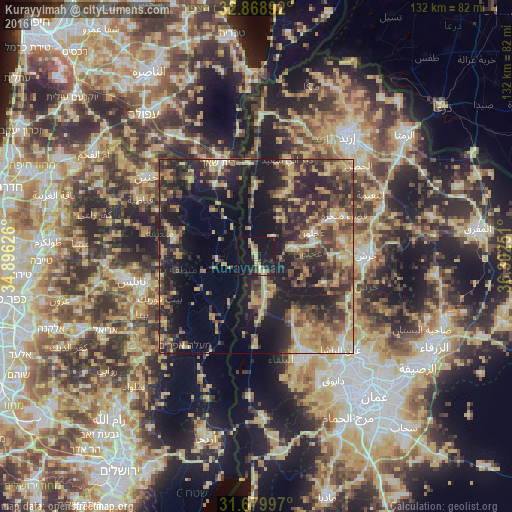
Analysis of Kurayyimah night lights 2016
Square area 10x10 km:
 0%
0%90-99
1.1%80-89
7.51%70-79
3.11%60-69
0.18%50-59
2.01%40-49
3.85%30-39
2.75%20-29
3.48%10-19
43.96%0-9
32.05%Square area 50x50 km:
1.15%90-99
2.1%80-89
6.4%70-79
6.18%60-69
4.77%50-59
4.4%40-49
7.92%30-39
7.7%20-29
12.65%10-19
19.16%0-9
27.59%Clear (daylight) street map image can be seen on geolist.org.
Map coordinates:
32° 52' 8.1" North, 34° 53' 46.5" East
32° 16' 35" North, 35° 35' 57.8" East
31° 40' 47.9" North, 36° 18' 9" East
Some cities around Kurayyimah sort by population:
• ‘Ajlūn
15.7 km =9.8 mi,  66°
66°
• Judita
17.8 km =11.1 mi,  34°
34°
• ‘Anjarah
15.1 km =9.4 mi,  77°
77°
• Sakib
19.7 km =12.2 mi,  87°
87°
• Ţammūn, PS
20.3 km =12.6 mi,  272°
272°
• ‘Ayn Jannah
16.7 km =10.4 mi, 67°
• Kafr Abīl
16.8 km =10.4 mi,  20°
20°
• Ḩalāwah
13.4 km =8.3 mi, 25°
248414 (p: 17,837)
Sources (retrieved 2019-11-25):
» Earth at Night: Flat Maps 2012, 2016