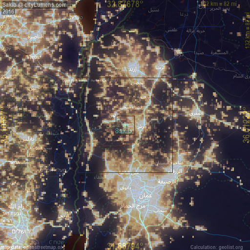
Sakib night lights from space
Night Light of Sakib (Jerash) from space (Jordan) Src. Average luminocity for 10x10km area is 56.3278% and for 50x50km: 41.3432%.
Analysis of Sakib night lights 2016
Square area 10x10 km:
100  3.66%
3.66%
90-99 5.49%
80-89 15.75%
70-79 7.69%
60-69 9.16%
50-59 12.64%
40-49 17.03%
30-39 13.55%
20-29 14.29%
10-19 0.73%
0-9 0%
3.66%90-99
5.49%80-89
15.75%70-79
7.69%60-69
9.16%50-59
12.64%40-49
17.03%30-39
13.55%20-29
14.29%10-19
0.73%0-9
0%Square area 50x50 km:
100 1.87%
90-99 3.34%
80-89 8.8%
70-79 7.94%
60-69 6.06%
50-59 6.89%
40-49 11.45%
30-39 9.6%
20-29 14.4%
10-19 20.7%
0-9 8.97%
1.87%90-99
3.34%80-89
8.8%70-79
7.94%60-69
6.06%50-59
6.89%40-49
11.45%30-39
9.6%20-29
14.4%10-19
20.7%0-9
8.97%Clear (daylight) street map image can be seen on geolist.org.
Map coordinates:
32° 52' 36.4" North, 35° 6' 21.5" East
32° 17' 3.5" North, 35° 48' 32.7" East
31° 41' 16.6" North, 36° 30' 44" East
Some cities around Sakib sort by population:
• ‘Ajlūn
7.6 km =4.7 mi,  315°
315°
• Jarash
8.5 km =5.3 mi,  92°
92°
• ‘Anjarah
5.5 km =3.4 mi,  296°
296°
• Sūf
4.2 km =2.6 mi,  38°
38°
• Şakhrah
10.1 km =6.3 mi,  18°
18°
• ‘Ayn Jannah
7 km =4.3 mi, 322°
• Raymūn
1.8 km =1.1 mi,  98°
98°
• Al Kittah
3.1 km =1.9 mi,  105°
105°
247068 (p: 11,586)
Sources (retrieved 2019-11-25):
» Earth at Night: Flat Maps 2012, 2016