Balīlā night lights from space
Night Light of Balīlā (Jerash) from space (Jordan) Src. Average luminocity for 10x10km area is 57.2839% and for 50x50km: 44.2778%.
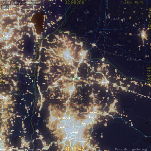
Analysis of Balīlā night lights 2016
Square area 10x10 km:
100  3.66%
3.66%
90-99 6.59%
80-89 16.12%
70-79 10.99%
60-69 7.14%
50-59 9.16%
40-49 18.32%
30-39 13.55%
20-29 11.72%
10-19 2.75%
0-9 0%
3.66%90-99
6.59%80-89
16.12%70-79
10.99%60-69
7.14%50-59
9.16%40-49
18.32%30-39
13.55%20-29
11.72%10-19
2.75%0-9
0%Square area 50x50 km:
100 3.15%
90-99 4.32%
80-89 9.56%
70-79 7.85%
60-69 5.94%
50-59 7.42%
40-49 11.89%
30-39 10.24%
20-29 15.84%
10-19 16.03%
0-9 7.76%
3.15%90-99
4.32%80-89
9.56%70-79
7.85%60-69
5.94%50-59
7.42%40-49
11.89%30-39
10.24%20-29
15.84%10-19
16.03%0-9
7.76%Clear (daylight) street map image can be seen on geolist.org.
Map coordinates:
32° 58' 58.3" North, 35° 14' 6.7" East
32° 23' 27.9" North, 35° 56' 18" East
31° 47' 43.5" North, 36° 38' 29.2" East
Some cities around Balīlā sort by population:
• Jarash
12.8 km =8 mi,  196°
196°
• Aydūn
14.8 km =9.2 mi,  329°
329°
• Sūf
12.8 km =8 mi,  227°
227°
• Şakhrah
9.3 km =5.8 mi,  255°
255°
• Rehab
16.2 km =10.1 mi,  117°
117°
• Raymūn
16 km =9.9 mi,  220°
220°
• Al Kittah
15.6 km =9.7 mi, 215°
• Kitim
6.5 km =4 mi,  323°
323°
250052 (p: 5,206)
Sources (retrieved 2019-11-25):
» Earth at Night: Flat Maps 2012, 2016