Villongo night lights from space
Night Light of Villongo (Lombardy) from space (Italy) Src. Average luminocity for 10x10km area is 52.1909% and for 50x50km: 43.7532%.
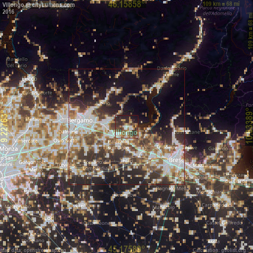
Analysis of Villongo night lights 2016
Square area 10x10 km:
 7.73%
7.73%90-99
10%80-89
5.61%70-79
5.45%60-69
7.42%50-59
12.27%40-49
6.36%30-39
17.12%20-29
17.42%10-19
10.3%0-9
0.3%Square area 50x50 km:
8.87%90-99
9.29%80-89
3.85%70-79
4.24%60-69
6.37%50-59
7.17%40-49
6.61%30-39
7.9%20-29
11.45%10-19
15.44%0-9
18.81%Clear (daylight) street map image can be seen on geolist.org.
Map coordinates:
46° 9' 30.9" North, 9° 13' 39.5" East
45° 40' 9.8" North, 9° 55' 50.7" East
45° 10' 33.2" North, 10° 38' 2" East
Some cities around Villongo sort by population:
• Castelli Calepio
7.2 km =4.5 mi,  209°
209°
• Capriolo
4 km =2.5 mi,  178°
178°
• Trescore Balneario
7.4 km =4.6 mi,  291°
291°
• Corte Franca
6.3 km =3.9 mi,  134°
134°
• Grumello del Monte
5.7 km =3.5 mi,  228°
228°
• Sarnico
2.4 km =1.5 mi,  85°
85°
• Adro
5.9 km =3.7 mi,  156°
156°
• Chiuduno
6.7 km =4.2 mi,  251°
251°
3164092 (p: 7,436)
Sources (retrieved 2019-11-25):
» Earth at Night: Flat Maps 2012, 2016