Chiuduno night lights from space
Night Light of Chiuduno (Lombardy) from space (Italy) Src. Average luminocity for 10x10km area is 72.4318% and for 50x50km: 45.7267%.
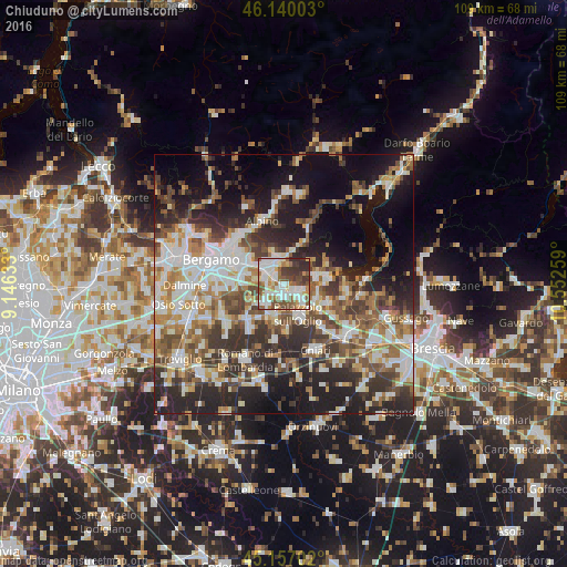
Analysis of Chiuduno night lights 2016
Square area 10x10 km:
 20.3%
20.3%90-99
21.36%80-89
5.91%70-79
4.55%60-69
11.21%50-59
12.42%40-49
9.24%30-39
10.3%20-29
4.7%10-19
0%0-9
0%Square area 50x50 km:
8.96%90-99
9.69%80-89
4.21%70-79
4.66%60-69
6.78%50-59
7.46%40-49
6.92%30-39
8.16%20-29
12.81%10-19
15.69%0-9
14.66%Clear (daylight) street map image can be seen on geolist.org.
Map coordinates:
46° 8' 24.1" North, 9° 8' 46.8" East
45° 39' 2.4" North, 9° 50' 58.1" East
45° 9' 25.3" North, 10° 33' 9.3" East
Some cities around Chiuduno sort by population:
• Palazzolo sull'Oglio
6.7 km =4.2 mi,  154°
154°
• Castelli Calepio
5 km =3.1 mi, 146°
• Capriolo
6.7 km =4.2 mi,  106°
106°
• Trescore Balneario
4.9 km =3 mi,  352°
352°
• Villongo
6.7 km =4.2 mi,  71°
71°
• Grumello del Monte
2.6 km =1.6 mi,  130°
130°
• Bolgare
3.4 km =2.1 mi,  233°
233°
• Calcinate
5.3 km =3.3 mi, 229°
6535164 (p: 5,434)
Sources (retrieved 2019-11-25):
» Earth at Night: Flat Maps 2012, 2016