Varazze night lights from space
Night Light of Varazze (Liguria) from space (Italy) Src. Average luminocity for 10x10km area is 18.3857% and for 50x50km: 9.4471%.
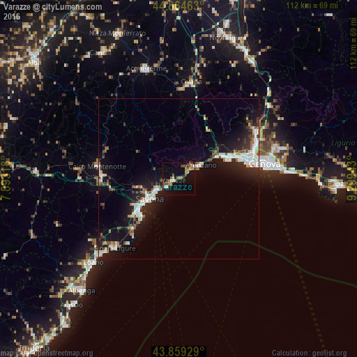
Analysis of Varazze night lights 2016
Square area 10x10 km:
 1.27%
1.27%90-99
1.75%80-89
0.79%70-79
2.86%60-69
4.44%50-59
3.02%40-49
4.92%30-39
1.9%20-29
1.9%10-19
11.43%0-9
65.71%Square area 50x50 km:
1.66%90-99
2.01%80-89
0.54%70-79
0.77%60-69
0.73%50-59
1.05%40-49
1.21%30-39
1.27%20-29
2.59%10-19
8.54%0-9
79.64%Clear (daylight) street map image can be seen on geolist.org.
Map coordinates:
44° 51' 52.7" North, 7° 53' 35.4" East
44° 21' 50.8" North, 8° 35' 46.7" East
43° 51' 33.4" North, 9° 17' 57.9" East
Some cities around Varazze sort by population:
• Savona
11.3 km =7 mi,  237°
237°
• Arenzano
8.3 km =5.2 mi,  56°
56°
• Albisola Superiore
7.4 km =4.6 mi,  247°
247°
• Vado Ligure
16.7 km =10.4 mi,  230°
230°
• Cogoleto
4.9 km =3 mi,  54°
54°
• Carcare
24.3 km =15.1 mi,  267°
267°
• Albisola Marina
7.8 km =4.8 mi, 241°
• Vado Centro
16.8 km =10.4 mi, 230°
3164709 (p: 11,534)
Sources (retrieved 2019-11-25):
» Earth at Night: Flat Maps 2012, 2016