Albisola Superiore night lights from space
Night Light of Albisola Superiore (Liguria) from space (Italy) Src. Average luminocity for 10x10km area is 33.1317% and for 50x50km: 8.4413%.
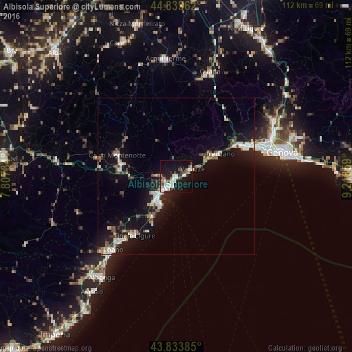
Analysis of Albisola Superiore night lights 2016
Square area 10x10 km:
 6.98%
6.98%90-99
8.73%80-89
1.59%70-79
2.22%60-69
2.06%50-59
3.97%40-49
5.24%30-39
2.38%20-29
7.78%10-19
33.33%0-9
25.71%Square area 50x50 km:
1.13%90-99
1.64%80-89
0.51%70-79
0.64%60-69
0.85%50-59
1.16%40-49
1.14%30-39
1.05%20-29
1.97%10-19
8.87%0-9
81.04%Clear (daylight) street map image can be seen on geolist.org.
Map coordinates:
44° 50' 22.6" North, 7° 48' 26.4" East
44° 20' 20" North, 8° 30' 37.7" East
43° 50' 1.9" North, 9° 12' 48.9" East
Some cities around Albisola Superiore sort by population:
• Savona
4.2 km =2.6 mi,  218°
218°
• Varazze
7.4 km =4.6 mi,  67°
67°
• Arenzano
15.6 km =9.7 mi,  61°
61°
• Cairo Montenotte
19.6 km =12.2 mi,  289°
289°
• Vado Ligure
9.9 km =6.2 mi, 218°
• Cogoleto
12.2 km =7.6 mi, 62°
• Carcare
17.6 km =10.9 mi,  275°
275°
• Vado Centro
10 km =6.2 mi, 218°
6534243 (p: 9,635)
Sources (retrieved 2019-11-25):
» Earth at Night: Flat Maps 2012, 2016