Vallo della Lucania night lights from space
Night Light of Vallo della Lucania (Campania) from space (Italy) Src. Average luminocity for 10x10km area is 16.9237% and for 50x50km: 10.2957%.
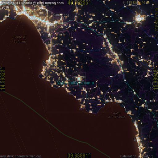
Analysis of Vallo della Lucania night lights 2016
Square area 10x10 km:
 0.97%
0.97%90-99
2.76%80-89
2.92%70-79
1.79%60-69
1.95%50-59
1.95%40-49
1.46%30-39
2.44%20-29
1.95%10-19
6.66%0-9
75.16%Square area 50x50 km:
0.31%90-99
0.82%80-89
1.47%70-79
1.45%60-69
1.7%50-59
2.05%40-49
1.23%30-39
1.85%20-29
2.84%10-19
7.77%0-9
78.52%Clear (daylight) street map image can be seen on geolist.org.
Map coordinates:
40° 45' 45.2" North, 14° 33' 47.6" East
40° 13' 40.3" North, 15° 15' 58.9" East
39° 41' 20.1" North, 15° 58' 10.1" East
Some cities around Vallo della Lucania sort by population:
• Battipaglia
48.7 km =30.3 mi,  330°
330°
• Eboli
46.8 km =29.1 mi,  337°
337°
• Agropoli
27 km =16.8 mi,  299°
299°
• Sala Consilina
33.6 km =20.9 mi,  55°
55°
• Sapri
35.4 km =22 mi,  118°
118°
• Quadrivio
46.3 km =28.8 mi, 342°
• Polla
37.4 km =23.2 mi,  31°
31°
• Lagonegro
43.6 km =27.1 mi,  104°
104°
3164794 (p: 6,899)
Sources (retrieved 2019-11-25):
» Earth at Night: Flat Maps 2012, 2016