Polla night lights from space
Night Light of Polla (Campania) from space (Italy) Src. Average luminocity for 10x10km area is 17.5969% and for 50x50km: 9.064%.
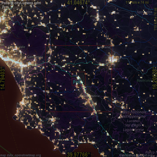
Analysis of Polla night lights 2016
Square area 10x10 km:
 0.85%
0.85%90-99
2.89%80-89
4.25%70-79
2.21%60-69
0.68%50-59
2.55%40-49
0.34%30-39
2.55%20-29
0.68%10-19
20.58%0-9
62.41%Square area 50x50 km:
0.34%90-99
1%80-89
1.24%70-79
1.01%60-69
1.2%50-59
1.61%40-49
1.21%30-39
2.05%20-29
2.15%10-19
6.25%0-9
81.93%Clear (daylight) street map image can be seen on geolist.org.
Map coordinates:
41° 2' 48.3" North, 14° 47' 38.5" East
40° 30' 51.6" North, 15° 29' 49.7" East
39° 58' 39.6" North, 16° 12' 1" East
Some cities around Polla sort by population:
• Potenza
29.8 km =18.5 mi,  61°
61°
• Battipaglia
44.8 km =27.8 mi,  283°
283°
• Eboli
38.9 km =24.2 mi,  287°
287°
• Sala Consilina
14.9 km =9.3 mi,  147°
147°
• Vallo della Lucania
37.4 km =23.2 mi,  211°
211°
• Olevano sul Tusciano
43.1 km =26.8 mi, 291°
• Quadrivio
35.4 km =22 mi, 290°
• Avigliano
30.7 km =19.1 mi,  37°
37°
3170376 (p: 5,182)
Sources (retrieved 2019-11-25):
» Earth at Night: Flat Maps 2012, 2016