Povegliano Veronese night lights from space
Night Light of Povegliano Veronese (Veneto) from space (Italy) Src. Average luminocity for 10x10km area is 51.9794% and for 50x50km: 39.9219%.
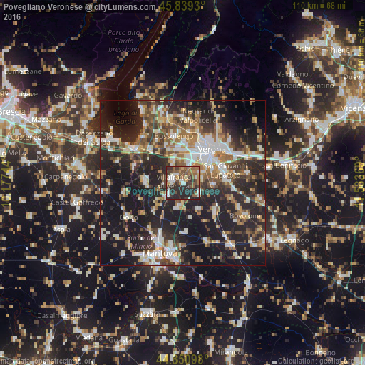
Analysis of Povegliano Veronese night lights 2016
Square area 10x10 km:
 7.62%
7.62%90-99
8.57%80-89
3.02%70-79
4.29%60-69
9.84%50-59
15.71%40-49
9.52%30-39
10.32%20-29
30.79%10-19
0.32%0-9
0%Square area 50x50 km:
5.98%90-99
7.5%80-89
3.76%70-79
4.13%60-69
5.54%50-59
6.4%40-49
6.07%30-39
6.4%20-29
16.73%10-19
28.38%0-9
9.1%Clear (daylight) street map image can be seen on geolist.org.
Map coordinates:
45° 50' 21.5" North, 10° 10' 38.8" East
45° 20' 50.3" North, 10° 52' 50" East
44° 51' 3.5" North, 11° 35' 1.3" East
Some cities around Povegliano Veronese sort by population:
• Verona
12.3 km =7.6 mi,  41°
41°
• Villafranca di Verona
2.9 km =1.8 mi,  284°
284°
• Beccacivetta-Azzano
7 km =4.3 mi,  64°
64°
• Valeggio sul Mincio
11.3 km =7 mi,  273°
273°
• Lugagnano
9.6 km =6 mi,  1°
1°
• Sommacampagna
7.1 km =4.4 mi,  336°
336°
• Vigasio
5.9 km =3.7 mi,  123°
123°
• Dossobuono
5.6 km =3.5 mi,  24°
24°
3170019 (p: 6,113)
Sources (retrieved 2019-11-25):
» Earth at Night: Flat Maps 2012, 2016