Castelnuovo del Garda night lights from space
Night Light of Castelnuovo del Garda (Veneto) from space (Italy) Src. Average luminocity for 10x10km area is 50.0111% and for 50x50km: 38.1373%.
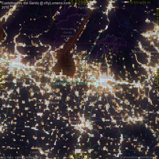
Analysis of Castelnuovo del Garda night lights 2016
Square area 10x10 km:
 4.29%
4.29%90-99
6.83%80-89
5.71%70-79
4.29%60-69
11.27%50-59
9.68%40-49
13.97%30-39
17.3%20-29
25.56%10-19
1.11%0-9
0%Square area 50x50 km:
5.43%90-99
6.8%80-89
3.53%70-79
4.01%60-69
5.82%50-59
6.41%40-49
6.39%30-39
7.19%20-29
15%10-19
24.54%0-9
14.88%Clear (daylight) street map image can be seen on geolist.org.
Map coordinates:
45° 55' 48" North, 10° 3' 24" East
45° 26' 19.6" North, 10° 45' 35.2" East
44° 56' 35.7" North, 11° 27' 46.5" East
Some cities around Castelnuovo del Garda sort by population:
• Villafranca di Verona
11.5 km =7.1 mi,  144°
144°
• Bussolengo
8.1 km =5 mi,  65°
65°
• Pescantina
9.9 km =6.2 mi,  58°
58°
• Sant'Ambrogio di Valpollicella
10.9 km =6.8 mi,  33°
33°
• Valeggio sul Mincio
9.7 km =6 mi,  190°
190°
• Lugagnano
9.7 km =6 mi,  93°
93°
• Peschiera del Garda
5.7 km =3.5 mi,  270°
270°
• Sommacampagna
7.5 km =4.7 mi,  119°
119°
6534221 (p: 5,341)
Sources (retrieved 2019-11-25):
» Earth at Night: Flat Maps 2012, 2016