Lugagnano night lights from space
Night Light of Lugagnano (Veneto) from space (Italy) Src. Average luminocity for 10x10km area is 79.6889% and for 50x50km: 34.8917%.
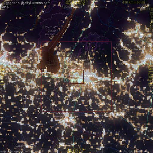
Analysis of Lugagnano night lights 2016
Square area 10x10 km:
 22.7%
22.7%90-99
21.27%80-89
9.37%70-79
8.89%60-69
21.75%50-59
11.43%40-49
2.38%30-39
1.9%20-29
0.32%10-19
0%0-9
0%Square area 50x50 km:
4.85%90-99
6.02%80-89
3.16%70-79
3.68%60-69
5.38%50-59
5.92%40-49
5.52%30-39
5.79%20-29
15.48%10-19
23.57%0-9
20.62%Clear (daylight) street map image can be seen on geolist.org.
Map coordinates:
45° 55' 28.3" North, 10° 10' 51.2" East
45° 25' 59.8" North, 10° 53' 2.5" East
44° 56' 15.7" North, 11° 35' 13.7" East
Some cities around Lugagnano sort by population:
• Verona
7.8 km =4.8 mi,  92°
92°
• Villafranca di Verona
9.3 km =5.8 mi,  199°
199°
• Bussolengo
4.6 km =2.9 mi,  329°
329°
• Pescantina
5.9 km =3.7 mi,  347°
347°
• Beccacivetta-Azzano
8.9 km =5.5 mi,  137°
137°
• Sommacampagna
4.4 km =2.7 mi,  225°
225°
• Dossobuono
4.9 km =3 mi,  155°
155°
• Arbizzano-Santa Maria
8.1 km =5 mi,  31°
31°
3174505 (p: 8,383)
Sources (retrieved 2019-11-25):
» Earth at Night: Flat Maps 2012, 2016