Gussago night lights from space
Night Light of Gussago (Lombardy) from space (Italy) Src. Average luminocity for 10x10km area is 70.0939% and for 50x50km: 38.0132%.
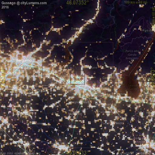
Analysis of Gussago night lights 2016
Square area 10x10 km:
 19.39%
90-99
18.33%80-89
4.85%70-79
7.73%60-69
12.12%50-59
11.67%40-49
6.97%30-39
10.91%20-29
8.03%10-19
0%0-9
0%Square area 50x50 km:
6.47%90-99
7.36%80-89
3.1%70-79
3.61%60-69
4.98%50-59
6.86%40-49
6.49%30-39
8.37%20-29
12.4%10-19
18.26%0-9
22.1%Clear (daylight) street map image can be seen on geolist.org.
Map coordinates:
46° 4' 24.7" North, 9° 27' 14.5" East
45° 35' 0.9" North, 10° 9' 25.8" East
45° 5' 21.6" North, 10° 51' 37.1" East
Some cities around Gussago sort by population:
• Piazza
0.4 km =0.2 mi,  339°
339°
• Concesio
5.2 km =3.2 mi,  62°
62°
• Villa Carcina
6.3 km =3.9 mi,  28°
28°
• Roncadelle
6.3 km =3.9 mi,  182°
182°
• Ponte Cingoli
4.2 km =2.6 mi,  291°
291°
• Castegnato
4.1 km =2.5 mi,  233°
233°
• Rodengo-Saiano
4.3 km =2.7 mi, 294°
• Bovezzo
6.6 km =4.1 mi,  83°
83°
3175670 (p: 14,502)
Sources (retrieved 2019-11-25):
» Earth at Night: Flat Maps 2012, 2016