Terralba night lights from space
Night Light of Terralba (Sardinia) from space (Italy) Src. Average luminocity for 10x10km area is 12.4383% and for 50x50km: 5.402%.
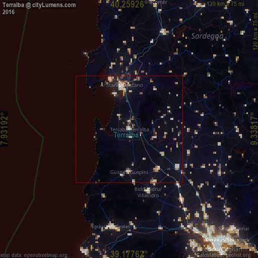
Analysis of Terralba night lights 2016
Square area 10x10 km:
 0%
0%90-99
2.44%80-89
0.32%70-79
2.44%60-69
1.95%50-59
1.62%40-49
3.08%30-39
2.44%20-29
2.11%10-19
2.11%0-9
81.49%Square area 50x50 km:
0.3%90-99
0.83%80-89
0.65%70-79
0.75%60-69
0.58%50-59
0.89%40-49
0.6%30-39
1.09%20-29
0.89%10-19
2.38%0-9
91.03%Clear (daylight) street map image can be seen on geolist.org.
Map coordinates:
40° 15' 33.3" North, 7° 55' 54.9" East
39° 43' 14" North, 8° 38' 6.1" East
39° 10' 39.4" North, 9° 20' 17.4" East
Some cities around Terralba sort by population:
• Oristano
20.7 km =12.9 mi,  349°
349°
• Villacidro
30.6 km =19 mi,  162°
162°
• Guspini
20.1 km =12.5 mi,  180°
180°
• San Gavino Monreale
23.2 km =14.4 mi,  144°
144°
• Sanluri
28.7 km =17.8 mi,  127°
127°
• Cabras
24.7 km =15.3 mi,  339°
339°
• Gonnosfanadiga
25.3 km =15.7 mi,  174°
174°
• Arbus
21.8 km =13.5 mi,  187°
187°
2522958 (p: 9,583)
Sources (retrieved 2019-11-25):
» Earth at Night: Flat Maps 2012, 2016