Oristano night lights from space
Night Light of Oristano (Sardinia) from space (Italy) Src. Average luminocity for 10x10km area is 34.2959% and for 50x50km: 5.0882%.
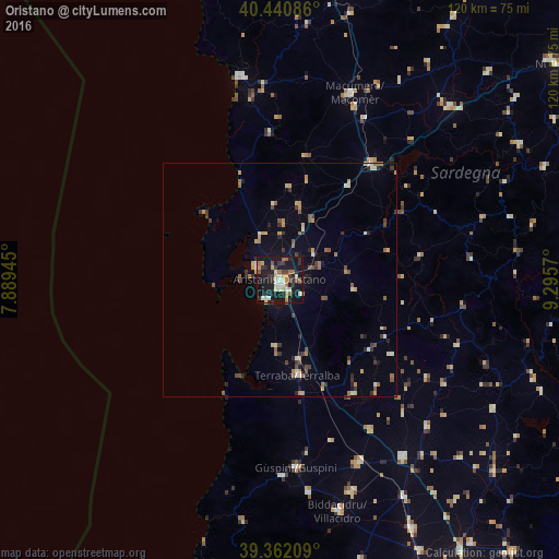

Analysis of Oristano night lights 2016
Square area 10x10 km:
 2.89%
2.89%90-99
7.48%80-89
3.74%70-79
5.27%60-69
4.08%50-59
4.08%40-49
2.38%30-39
6.63%20-29
6.97%10-19
49.49%0-9
6.97%Square area 50x50 km:
0.17%90-99
0.81%80-89
0.46%70-79
0.88%60-69
0.63%50-59
0.8%40-49
0.69%30-39
1.01%20-29
0.88%10-19
2.88%0-9
90.77%Clear (daylight) street map image can be seen on geolist.org.
Map coordinates:
40° 26' 27.1" North, 7° 53' 22" East
39° 54' 13" North, 8° 35' 33.3" East
39° 21' 43.5" North, 9° 17' 44.5" East
Some cities around Oristano sort by population:
• Guspini
40.6 km =25.2 mi,  174°
174°
• Macomer
42.6 km =26.5 mi,  20°
20°
• Terralba
20.7 km =12.9 mi, 169°
• San Gavino Monreale
42.8 km =26.6 mi,  156°
156°
• Bosa
44.7 km =27.8 mi,  349°
349°
• Cabras
5.8 km =3.6 mi,  298°
298°
• Gonnosfanadiga
45.9 km =28.5 mi, 172°
• Arbus
42 km =26.1 mi,  179°
179°
2523964 (p: 24,641)
Sources (retrieved 2019-11-25):
» Earth at Night: Flat Maps 2012, 2016