Gonnosfanadiga night lights from space
Night Light of Gonnosfanadiga (Sardinia) from space (Italy) Src. Average luminocity for 10x10km area is 6.1364% and for 50x50km: 5.5944%.
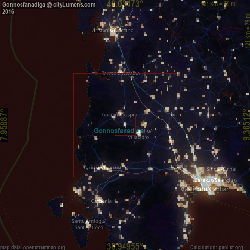
Analysis of Gonnosfanadiga night lights 2016
Square area 10x10 km:
 0.97%
0.97%90-99
0.32%80-89
0%70-79
1.3%60-69
0.65%50-59
0.65%40-49
0%30-39
1.79%20-29
0.32%10-19
1.14%0-9
92.86%Square area 50x50 km:
0.38%90-99
0.72%80-89
0.85%70-79
0.95%60-69
0.65%50-59
0.64%40-49
0.42%30-39
0.78%20-29
0.9%10-19
1.59%0-9
92.12%Clear (daylight) street map image can be seen on geolist.org.
Map coordinates:
40° 2' 5" North, 7° 57' 31.9" East
39° 29' 39.3" North, 8° 39' 43.2" East
38° 56' 58.4" North, 9° 21' 54.4" East
Some cities around Gonnosfanadiga sort by population:
• Iglesias
23.2 km =14.4 mi,  207°
207°
• Villacidro
7.9 km =4.9 mi,  121°
121°
• Guspini
5.5 km =3.4 mi,  335°
335°
• San Gavino Monreale
12.7 km =7.9 mi,  60°
60°
• Sanluri
21.7 km =13.5 mi,  69°
69°
• Domusnovas
19 km =11.8 mi,  183°
183°
• Arbus
6.4 km =4 mi,  303°
303°
• Samassi
20.9 km =13 mi,  93°
93°
2524587 (p: 6,423)
Sources (retrieved 2019-11-25):
» Earth at Night: Flat Maps 2012, 2016