Subiaco night lights from space
Night Light of Subiaco (Latium) from space (Italy) Src. Average luminocity for 10x10km area is 15.8222% and for 50x50km: 16.0538%.
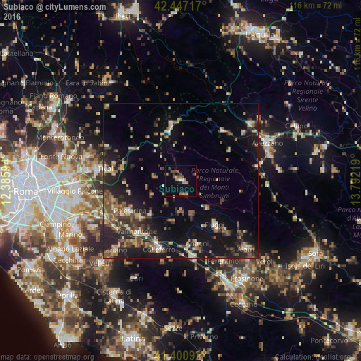
Analysis of Subiaco night lights 2016
Square area 10x10 km:
 0.79%
0.79%90-99
0.48%80-89
1.27%70-79
3.81%60-69
3.17%50-59
2.7%40-49
3.49%30-39
2.06%20-29
0.63%10-19
3.33%0-9
78.25%Square area 50x50 km:
0.84%90-99
2.1%80-89
1.68%70-79
2.03%60-69
2.05%50-59
2.85%40-49
2.99%30-39
2.71%20-29
5.83%10-19
13.66%0-9
63.24%Clear (daylight) street map image can be seen on geolist.org.
Map coordinates:
42° 26' 49.8" North, 12° 23' 9.4" East
41° 55' 34.3" North, 13° 5' 20.6" East
41° 24' 3.3" North, 13° 47' 31.9" East
Some cities around Subiaco sort by population:
• Palestrina
20.1 km =12.5 mi,  238°
238°
• Valmontone
22.1 km =13.7 mi,  219°
219°
• Fiuggi
18.1 km =11.2 mi,  141°
141°
• Anagni
21 km =13 mi,  164°
164°
• Cave
17.3 km =10.7 mi,  225°
225°
• Castel Madama
19 km =11.8 mi,  286°
286°
• Paliano
16.3 km =10.1 mi,  183°
183°
• Olevano Romano
8.7 km =5.4 mi,  210°
210°
3166052 (p: 6,025)
Sources (retrieved 2019-11-25):
» Earth at Night: Flat Maps 2012, 2016