Anagni night lights from space
Night Light of Anagni (Latium) from space (Italy) Src. Average luminocity for 10x10km area is 27.3766% and for 50x50km: 19.5843%.
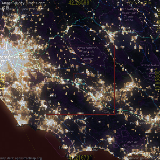
Analysis of Anagni night lights 2016
Square area 10x10 km:
 2.11%
2.11%90-99
6.33%80-89
2.44%70-79
3.9%60-69
2.76%50-59
2.92%40-49
0.97%30-39
2.44%20-29
7.14%10-19
51.62%0-9
17.37%Square area 50x50 km:
1.11%90-99
2.6%80-89
2.03%70-79
2.17%60-69
2.42%50-59
3.78%40-49
3.76%30-39
4.24%20-29
6.91%10-19
17.81%0-9
53.16%Clear (daylight) street map image can be seen on geolist.org.
Map coordinates:
42° 15' 57.5" North, 12° 27' 8.3" East
41° 44' 36.6" North, 13° 9' 19.5" East
41° 13' 0.2" North, 13° 51' 30.8" East
Some cities around Anagni sort by population:
• Colleferro
12.6 km =7.8 mi,  261°
261°
• Ferentino
10.2 km =6.3 mi,  124°
124°
• Alatri
15.5 km =9.6 mi,  94°
94°
• Fiuggi
8.3 km =5.2 mi,  43°
43°
• Segni
12.8 km =8 mi,  241°
241°
• Paliano
7.7 km =4.8 mi,  301°
301°
• Olevano Romano
16.2 km =10.1 mi,  322°
322°
• Tecchiena
16.9 km =10.5 mi,  111°
111°
3183098 (p: 9,206)
Sources (retrieved 2019-11-25):
» Earth at Night: Flat Maps 2012, 2016