Vazzola night lights from space
Night Light of Vazzola (Veneto) from space (Italy) Src. Average luminocity for 10x10km area is 33.9003% and for 50x50km: 37.3149%.
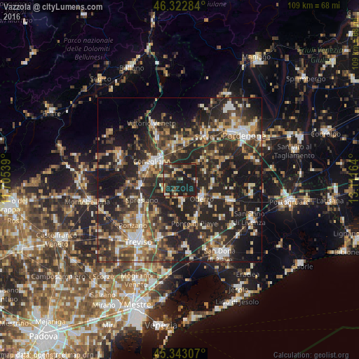
Analysis of Vazzola night lights 2016
Square area 10x10 km:
 0.74%
0.74%90-99
4.61%80-89
4.02%70-79
4.46%60-69
3.72%50-59
4.02%40-49
7.74%30-39
7.89%20-29
20.09%10-19
42.71%0-9
0%Square area 50x50 km:
3.68%90-99
6.21%80-89
3.59%70-79
4.15%60-69
5.6%50-59
6.42%40-49
7.55%30-39
8%20-29
18.17%10-19
24.34%0-9
12.3%Clear (daylight) street map image can be seen on geolist.org.
Map coordinates:
46° 19' 22.2" North, 11° 42' 19.4" East
45° 50' 6.4" North, 12° 24' 30.6" East
45° 20' 35.1" North, 13° 6' 41.9" East
Some cities around Vazzola sort by population:
• Conegliano
10.1 km =6.3 mi,  305°
305°
• Oderzo
9 km =5.6 mi,  132°
132°
• San Vendemiano
7.3 km =4.5 mi,  322°
322°
• Santa Lucia di Piave
9.4 km =5.8 mi,  288°
288°
• Mareno di Piave
5.7 km =3.5 mi,  282°
282°
• Priula-Colfosco
11.7 km =7.3 mi,  261°
261°
• San Vendemiano-Fossamerlo
8.8 km =5.5 mi, 316°
• Brugnera
12.6 km =7.8 mi,  55°
55°
3164665 (p: 5,283)
Sources (retrieved 2019-11-25):
» Earth at Night: Flat Maps 2012, 2016